Page Summary
-
This dataset, providing precipitation estimates from the GPM mission, has been superseded by a newer version.
-
The dataset covers the period from June 1, 2000, to June 2, 2024, with data available every 30 minutes.
-
GPM IMERG uses a unified algorithm combining satellite microwave and infrared data, as well as gauge analyses, to provide global rainfall estimates.
-
Data products in this collection are initially provisional and later updated to a permanent version.
-
All NASA-produced data from the GPM mission is freely available for public use.
- Dataset Availability
- 2000-06-01T00:00:00Z–2024-06-02T18:30:00Z
- Dataset Producer
- NASA GES DISC at NASA Goddard Space Flight Center
- Cadence
- 30 Minutes
- Tags
Description
Global Precipitation Measurement (GPM) is an international satellite mission to provide next-generation observations of rain and snow worldwide every three hours. The Integrated Multi-satellitE Retrievals for GPM (IMERG) is the unified algorithm that provides rainfall estimates combining data from all passive-microwave instruments in the GPM Constellation.
This algorithm is intended to intercalibrate, merge, and interpolate all satellite microwave precipitation estimates, together with microwave-calibrated infrared (IR) satellite estimates, precipitation gauge analyses, and potentially other precipitation estimators at fine time and space scales for the TRMM and GPM eras over the entire globe. The system is run several times for each observation time, first giving a quick estimate and successively providing better estimates as more data arrive. The final step uses monthly gauge data to create research-level products. See IMERG Technical Documentation for more details on the algorithm.
Documentation:
This collection contains provisional products that are regularly replaced with updated versions when the data become available. The products are marked with a metadata property called 'status'. When a product is initially made available, the property value is 'provisional'. Once a provisional product has been updated with the final version, this value is updated to 'permanent'.
This collection contains data from:
- GPM_3IMERGHH_V06 doi:10.5067/GPM/IMERG/3B-HH-L/06
- GPM_3IMERGHH_06 doi:10.5067/GPM/IMERG/3B-HH/06
Bands
Pixel Size
11132 meters
Bands
| Name | Units | Min | Max | Pixel Size | Description | ||||||||||||||||||||||||||||||||||||||||||||||||||||||||||||||||||||||||||||||||||||||||||||||
|---|---|---|---|---|---|---|---|---|---|---|---|---|---|---|---|---|---|---|---|---|---|---|---|---|---|---|---|---|---|---|---|---|---|---|---|---|---|---|---|---|---|---|---|---|---|---|---|---|---|---|---|---|---|---|---|---|---|---|---|---|---|---|---|---|---|---|---|---|---|---|---|---|---|---|---|---|---|---|---|---|---|---|---|---|---|---|---|---|---|---|---|---|---|---|---|---|---|---|---|
HQobservationTime |
min. into half hour | 0* | 29* | meters | PMW source time |
||||||||||||||||||||||||||||||||||||||||||||||||||||||||||||||||||||||||||||||||||||||||||||||
HQprecipSource |
meters | PMW source sensor identifier |
|||||||||||||||||||||||||||||||||||||||||||||||||||||||||||||||||||||||||||||||||||||||||||||||||
HQprecipitation |
mm/hr | 0* | 120* | meters | merged PMW precipitation |
||||||||||||||||||||||||||||||||||||||||||||||||||||||||||||||||||||||||||||||||||||||||||||||
IRkalmanFilterWeight |
% | 0* | 100* | meters | Kalman filter weight for IR |
||||||||||||||||||||||||||||||||||||||||||||||||||||||||||||||||||||||||||||||||||||||||||||||
IRprecipitation |
mm/hr | 0* | 79.5* | meters | IR precipitation |
||||||||||||||||||||||||||||||||||||||||||||||||||||||||||||||||||||||||||||||||||||||||||||||
precipitationCal |
mm/hr | 0* | 174* | meters | snapshot precipitation - calibrated |
||||||||||||||||||||||||||||||||||||||||||||||||||||||||||||||||||||||||||||||||||||||||||||||
precipitationUncal |
mm/hr | 0* | 120* | meters | snapshot precipitation - uncalibrated |
||||||||||||||||||||||||||||||||||||||||||||||||||||||||||||||||||||||||||||||||||||||||||||||
probabilityLiquidPrecipitation |
% | 0* | 100* | meters | probability of liquid precipitation phase |
||||||||||||||||||||||||||||||||||||||||||||||||||||||||||||||||||||||||||||||||||||||||||||||
randomError |
mm/hr | 0.24* | 250* | meters | calibrated-precipitation random error |
||||||||||||||||||||||||||||||||||||||||||||||||||||||||||||||||||||||||||||||||||||||||||||||
Terms of Use
Terms of Use
All NASA-produced data from the GPM mission is made freely available for the public to use.
Citations
Huffman, G.J., E.F. Stocker, D.T. Bolvin, E.J. Nelkin, Jackson Tan (2019), GPM IMERG Final Precipitation L3 Half Hourly 0.1 degree x 0.1 degree V06, Greenbelt, MD, Goddard Earth Sciences Data and Information Services Center (GES DISC), Accessed: [Data Access Date], doi:10.5067/GPM/IMERG/3B-HH/06
DOIs
Explore with Earth Engine
Code Editor (JavaScript)
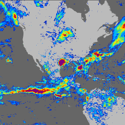
// GPM V6 30 minute data around hurricane Dorian for a single day.
var range = ee.Date('2019-09-03').getRange('day');
var dataset = ee.ImageCollection('NASA/GPM_L3/IMERG_V06')
    .filter(ee.Filter.date(range));

// Select the max precipitation and mask out low precipitation values.
var precipitation = dataset.select('precipitationCal').max();
var mask = precipitation.gt(0.5);
var precipitation = precipitation.updateMask(mask);

var palette = [
  '000096','0064ff', '00b4ff', '33db80', '9beb4a',
  'ffeb00', 'ffb300', 'ff6400', 'eb1e00', 'af0000'
];
var precipitationVis = {min: 0, max: 15, palette: palette};
Map.addLayer(precipitation, precipitationVis, 'Precipitation (mm/hr)');
Map.setCenter(-76, 33, 3);