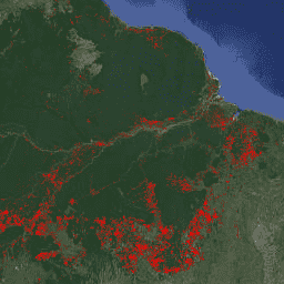
FORMA is a MODIS-based deforestation alerting system for the humid tropical
forests. FORMA is designed for quick identification of new areas of tree
cover loss. The system analyzes data gathered daily by the MODIS sensor,
which operates on NASA's Terra and Aqua satellites. The FORMA alerts system
then detects pronounced changes in vegetation cover over time, as measured
by the Normalized Difference Vegetation Index (NDVI), a measure of
vegetation greenness. These pronounced changes in vegetation cover are
likely to indicate forest being cleared, burned, or defoliated. An alert is
added to the dataset by setting the pixel value to the date at which a
change was detected. FORMA alerts only appear in areas where the probability
of tree cover loss is greater than or equal to 50%. FORMA data has 500-meter
spatial resolution and twice-monthly update interval. FORMA alerts start in
January 2006.
The FORMA datasets are available without restriction on use or distribution.
WRI does request that the user give proper attribution and identify WRI and
GFW, where applicable, as the source of the data.
Citations
Citations:
Hammer, Dan, Robin Kraft, and David Wheeler. 2013. FORMA Alerts. World
Resources Institute and Center for Global Development.
www.globalforestwatch.org.
FORMA is a MODIS-based deforestation alerting system for the humid tropical forests. FORMA is designed for quick identification of new areas of tree cover loss. The system analyzes data gathered daily by the MODIS sensor, which operates on NASA's Terra and Aqua satellites. The FORMA alerts system then detects pronounced …
[[["Easy to understand","easyToUnderstand","thumb-up"],["Solved my problem","solvedMyProblem","thumb-up"],["Other","otherUp","thumb-up"]],[["Missing the information I need","missingTheInformationINeed","thumb-down"],["Too complicated / too many steps","tooComplicatedTooManySteps","thumb-down"],["Out of date","outOfDate","thumb-down"],["Samples / code issue","samplesCodeIssue","thumb-down"],["Other","otherDown","thumb-down"]],[],[[["\u003cp\u003eFORMA is a MODIS-based deforestation alerting system for the humid tropical forests designed for quick identification of new areas of tree cover loss.\u003c/p\u003e\n"],["\u003cp\u003eThe system analyzes data from NASA's Terra and Aqua satellites to detect pronounced changes in vegetation cover, indicating potential forest clearing, burning, or defoliation.\u003c/p\u003e\n"],["\u003cp\u003eFORMA alerts are generated for areas with a probability of tree cover loss greater than or equal to 50% and are represented by pixel values corresponding to the date of change detection.\u003c/p\u003e\n"],["\u003cp\u003eThis dataset has been superseded by WRI/GFW/FORMA/alerts and has a spatial resolution of 500 meters with a twice-monthly update interval, covering the period from January 2006 to June 2015.\u003c/p\u003e\n"],["\u003cp\u003eThe FORMA datasets are available without restriction on use or distribution, with proper attribution requested to WRI and GFW as the data source.\u003c/p\u003e\n"]]],["FORMA, a MODIS-based system, identifies new tree cover loss in humid tropical forests by analyzing daily data from NASA's Terra and Aqua satellites. It uses the Normalized Difference Vegetation Index (NDVI) to detect changes indicative of clearing, burning, or defoliation. Alerts, represented by pixel values set to the change detection date, appear where tree cover loss probability is ≥50%. The data, updated twice-monthly, has a 500-meter spatial resolution and covers January 2006 to June 2015. This data is now deprecated.\n"],null,["# FORMA Global Forest Watch Deforestation Alerts, 500m [deprecated]\n\n**Caution:** This dataset has been superseded by [WRI/GFW/FORMA/alerts](/earth-engine/datasets/catalog/WRI_GFW_FORMA_alerts). \n\nDataset Availability\n: 2006-01-01T00:00:00Z--2015-06-10T00:00:00Z\n\nDataset Provider\n:\n\n\n [Global Forest Watch, World Resources Institute](https://www.globalforestwatch.org)\n\nTags\n:\n alerts \n deforestation \n fire \n forest \n forma \n geophysical \n gfw \n modis \n nasa \nwri \n\n#### Description\n\nFORMA is a MODIS-based deforestation alerting system for the humid tropical\nforests. FORMA is designed for quick identification of new areas of tree\ncover loss. The system analyzes data gathered daily by the MODIS sensor,\nwhich operates on NASA's Terra and Aqua satellites. The FORMA alerts system\nthen detects pronounced changes in vegetation cover over time, as measured\nby the Normalized Difference Vegetation Index (NDVI), a measure of\nvegetation greenness. These pronounced changes in vegetation cover are\nlikely to indicate forest being cleared, burned, or defoliated. An alert is\nadded to the dataset by setting the pixel value to the date at which a\nchange was detected. FORMA alerts only appear in areas where the probability\nof tree cover loss is greater than or equal to 50%. FORMA data has 500-meter\nspatial resolution and twice-monthly update interval. FORMA alerts start in\nJanuary 2006.\n\n### Bands\n\n\n**Pixel Size**\n\n500 meters\n\n**Bands**\n\n| Name | Units | Min | Max | Pixel Size | Description |\n|------------|---------|---------------|---------------|------------|----------------------------------------------------------------------|\n| `constant` | seconds | 1.13498e+09\\* | 1.43392e+09\\* | meters | [Seconds since Jan 1, 1970](https://en.wikipedia.org/wiki/Unix_time) |\n\n\\* estimated min or max value\n\n### Terms of Use\n\n**Terms of Use**\n\nThe FORMA datasets are available without restriction on use or distribution.\nWRI does request that the user give proper attribution and identify WRI and\nGFW, where applicable, as the source of the data.\n\n### Citations\n\nCitations:\n\n- Hammer, Dan, Robin Kraft, and David Wheeler. 2013. FORMA Alerts. World\n Resources Institute and Center for Global Development.\n [www.globalforestwatch.org](/earth-engine/datasets/catalog/www.globalforestwatch.org).\n\n### Explore with Earth Engine\n\n| **Important:** Earth Engine is a platform for petabyte-scale scientific analysis and visualization of geospatial datasets, both for public benefit and for business and government users. Earth Engine is free to use for research, education, and nonprofit use. To get started, please [register for Earth Engine access.](https://console.cloud.google.com/earth-engine)\n\n### Code Editor (JavaScript)\n\n```javascript\nvar dataset = ee.Image('FORMA/FORMA_500m');\n\nvar visualization = {\n bands: ['constant'],\n min: 1134979200.0,\n max: 1433919600.0,\n palette: ['ff0000']\n};\n\nMap.setCenter(-51.482, -0.835, 6);\n\nMap.addLayer(dataset, visualization, 'Alert Areas');\n```\n[Open in Code Editor](https://code.earthengine.google.com/?scriptPath=Examples:Datasets/FORMA/FORMA_FORMA_500m) \n[FORMA Global Forest Watch Deforestation Alerts, 500m \\[deprecated\\]](/earth-engine/datasets/catalog/FORMA_FORMA_500m) \nFORMA is a MODIS-based deforestation alerting system for the humid tropical forests. FORMA is designed for quick identification of new areas of tree cover loss. The system analyzes data gathered daily by the MODIS sensor, which operates on NASA's Terra and Aqua satellites. The FORMA alerts system then detects pronounced ... \nFORMA/FORMA_500m, alerts,deforestation,fire,forest,forma,geophysical,gfw,modis,nasa,wri \n2006-01-01T00:00:00Z/2015-06-10T00:00:00Z \n-90 -180 90 180 \nGoogle Earth Engine \nhttps://developers.google.com/earth-engine/datasets\n\n- [](https://doi.org/https://www.globalforestwatch.org)\n- [](https://doi.org/https://developers.google.com/earth-engine/datasets/catalog/FORMA_FORMA_500m)"]]