- データセットの利用可能な期間
- 2014-12-19T16:45:00Z–2014-12-19T16:45:00Z
- データセット プロデューサー
- FAO UN
- タグ
説明
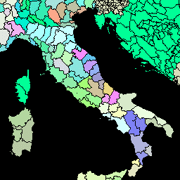
このバージョンの GAUL データセットは 500 m で簡略化されています。
Global Administrative Unit Layers(GAUL)は、世界のすべての国について、利用可能な最良の行政単位に関する情報を収集して配布し、行政単位を表す空間データセットの標準化に貢献しています。GAUL は、国、第 1 レベル(部門など)、第 2 レベル(地区など)の行政レベルで統一されたコーディング システムを使用して、常にグローバル レイヤを維持します。データが利用可能な場合は、国ごとにレイヤが提供され、3 番目、4 番目、それ以下のレベルまで表示されます。全体的な方法論は、a) 最も信頼できるソースから入手可能な最良のデータを収集する、b) 地理的特徴の検証期間を設定する(可能な場合)、c) 国連地図作成ユニット(UNCS)が提供した最新の国境地図に基づいて、選択したデータをグローバル レイヤに追加する、d) GAUL コーディング システムを使用してコードを生成する、e) ユーザーにデータを配布する(GAUL 配布セットの技術的側面を参照)で構成されています。一部の行政単位はマルチポリゴン フィーチャーです。
テーブル スキーマ
テーブル スキーマ
| 名前 | 型 | 説明 |
|---|---|---|
| ADM0_CODE | INT | GAUL 国コード |
| ADM0_NAME | STRING | 国連の国名 |
| DISP_AREA | STRING | 未確定の領土: 「はい」または「いいえ」 |
| ステータス | STRING | 国のステータス |
| Shape_Area | DOUBLE | シェイプの面積 |
| Shape_Leng | DOUBLE | シェイプの長さ |
| ADM1_CODE | INT | 第 1 レベルの行政単位の GAUL コード |
| ADM1_NAME | STRING | 第 1 レベルの行政単位の名前 |
| ADM2_CODE | INT | 第 2 レベルの行政単位の GAUL コード |
| ADM2_NAME | STRING | 第 2 レベルの行政単位の名前 |
| EXP2_YEAR | INT | 管理単位の有効期限年 |
| STR2_YEAR | INT | 行政単位の作成年 |
利用規約
利用規約
GAUL データセットは、国連やその他の認可された国際機関や国内機関に配布されます。FAO は、GAUL データセットに含まれる資料を非営利目的でのみ、データ ライセンスに指定された条件に従って使用、ダウンロード、印刷するライセンスを付与します。GAUL データライセンスの全文をダウンロードできます。免責事項もご覧ください。
Earth Engine で探索する
コードエディタ(JavaScript)
var dataset = ee.FeatureCollection('FAO/GAUL_SIMPLIFIED_500m/2015/level2');

Map.setCenter(12.876, 42.682, 5);

var styleParams = {
  fillColor: 'b5ffb4',
  color: '00909F',
  width: 1.0,
};

dataset = dataset.style(styleParams);

Map.addLayer(dataset, {}, 'Second Level Administrative Units');