Page Summary
-
The U.S. Environmental Protection Agency (USEPA) provides the Ecoregions dataset as a spatial framework for ecosystem research, assessment, management, and monitoring.
-
Ecoregions identify areas with general similarities in ecosystems and environmental resources.
-
The dataset includes both the USEPA and Commission for Environmental Cooperation (CEC) ecoregion classification schemes, which are hierarchical.
-
This ingested dataset contains features for the conterminous United States only.
- Dataset Availability
- 2013-04-16T00:00:00Z–2013-04-17T00:00:00Z
- Dataset Producer
- United States Environmental Protection Agency
- Tags
Description
The U.S. Environmental Protection Agency (USEPA) provides the Ecoregions dataset to serve as a spatial framework for the research, assessment, management, and monitoring of ecosystems and ecosystem components. Ecoregions denote areas of general similarity in ecosystems and in the type, quality, and quantity of environmental resources. These general-purpose regions are critical for structuring and implementing ecosystem management strategies across federal agencies, state agencies, and nongovernmental organizations that are responsible for different types of resources within the same geographical areas.
The approach used to compile this map is based on the premise that ecological regions can be identified through the analysis of patterns of biotic and abiotic phenomena, including geology, physiography, vegetation, climate, soils, land use, wildlife, and hydrology. The relative importance of each characteristic varies from one ecological region to another.
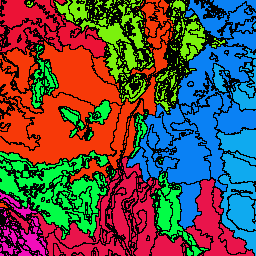
This dataset includes the USEPA ecoregions classification scheme, as well as the scheme from the Commission for Environmental Cooperation (CEC). Ecoregions are hierarchical, with Level IV being the most detailed and Level I defining the broadest classifications. Because of this hierarchy, Level III features retain information from Levels I and II. The CEC divided all of North America in distinct ecoregions for Levels I, II, and III, while the USEPA did so only for the United States at Level III and Level IV. The columns starting with 'us' belong to the USEPA scheme, and the columns starting with 'na' belong to the CEC scheme. The ingested version of this dataset contains features for the conterminous United States only (that is, Alaska and Hawaii are not included). Methods used to define the ecoregions are explained in Omernik (1995, 2004), Omernik and others (2000), and Gallant and others (1989).
*Calculated by the data provider.
Table Schema
Table Schema
| Name | Type | Description |
|---|---|---|
| l1_key | STRING | NA Level I Code and Name |
| l2_key | STRING | NA Level II Code and Name |
| l3_key | STRING | US Level III Code and Name |
| na_l1code | STRING | Code for Level I Ecoregion (North America/CEC) |
| na_l1name | STRING | Name for Level I Ecoregion (North America/CEC) |
| na_l2code | STRING | Code for Level II Ecoregion (North America/CEC) |
| na_l2name | STRING | Name for Level II Ecoregion (North America/CEC) |
| na_l3code | STRING | Code for Level III Ecoregion (North America/CEC) |
| na_l3name | STRING | Name for Level III Ecoregion (North America/CEC) |
| shape_area | DOUBLE | Area of the feature's geometry in its original format |
| shape_leng | DOUBLE | Length of the edges in the feature's geometry in its original format |
| us_l3code | STRING | Code for Level III Ecoregion (US/USEPA) |
| us_l3name | STRING | Name for Level III Ecoregion (US/USEPA) |
Terms of Use
Terms of Use
There are no restrictions on use of this US public domain data.
Citations
Commission for Environmental Cooperation. 1997. Ecological regions of North America: toward a common perspective. Commission for Environmental Cooperation, Montreal, Quebec, Canada. 71p. Map (scale 1:12,500,000). Revised 2006.
McMahon, G., S.M. Gregonis, S.W. Waltman, J.M. Omernik, T.D. Thorson, J.A. Freeouf, A.H. Rorick, and J.E. Keys. 2001. Developing a spatial framework of common ecological regions for the conterminous United States. Environmental Management 28(3):293-316.
Omernik, J.M. 1987. Ecoregions of the conterminous United States. Map (scale 1:7,500,000). Annals of the Association of American Geographers 77(1):118-125.
Omernik, J.M. 1995. Ecoregions: A spatial framework for environmental management. In: Biological Assessment and Criteria: Tools for Water Resource Planning and Decision Making. Davis, W.S. and T.P. Simon (eds.), Lewis Publishers, Boca Raton, FL. p. 49-62.
Omernik, J.M. 2004. Perspectives on the nature and definition of ecological regions. Environmental Management 34(Supplement 1):S27-S38.
Omernik, J.M. and G.E. Griffith. 2014. Ecoregions of the conterminous United States: evolution of a hierarchical spatial framework. Environmental Management 54(6):1249-1266.
Explore with Earth Engine
Code Editor (JavaScript)
var dataset = ee.FeatureCollection('EPA/Ecoregions/2013/L3');
var visParams = {
  palette: ['0a3b04', '1a9924', '15d812'],
  min: 23.0,
  max: 3.57e+11,
  opacity: 0.8,
};
var image = ee.Image().float().paint(dataset, 'shape_area');
Map.setCenter(-99.814, 40.166, 5);
Map.addLayer(image, visParams, 'EPA/Ecoregions/2013/L3');
Map.addLayer(dataset, null, 'for Inspector', false);
Visualize as a FeatureView
A FeatureView is a view-only, accelerated representation of a
FeatureCollection. For more details, visit the
FeatureView documentation.
Code Editor (JavaScript)
var fvLayer = ui.Map.FeatureViewLayer('EPA/Ecoregions/2013/L3_FeatureView');

var visParams = {
  color: {
    property: 'shape_area',
    mode: 'linear',
    palette: ['0a3b04', '1a9924', '15d812'],
    min: 23.0,
    max: 3.57e+11
  },
  opacity: 0.8,
  polygonStrokeOpacity: 0
};

fvLayer.setVisParams(visParams);
fvLayer.setName('EPA/Ecoregions/2013/L3');

Map.setCenter(-99.814, 40.166, 5);
Map.add(fvLayer);