

В этом руководстве пошагово описано, как создать и использовать стиль карты в светлом режиме, который выделяет дорожную сеть:
Создайте и опубликуйте стиль карты , чтобы он стал доступен для использования.
Создайте и подключите идентификатор карты , который позволит вам использовать свой стиль в приложениях и на веб-сайтах.
Добавьте идентификатор карты в свои приложения и веб-сайты , чтобы ваши приложения использовали ваш стиль карты.
Шаг 1: Создайте и опубликуйте стиль карты.
Открытая облачная стилизация карт
Перейдите в консоль Google Cloud и выберите «Стили карт» . При необходимости выберите или создайте проект.
Выберите «Создать стиль» .
Выберите «Свет» .
В нижней части диалогового окна выберите «Настроить» .
Сеть Style the Road
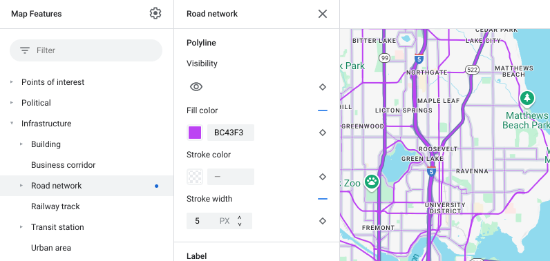
В разделе «Объекты карты» разверните «Инфраструктура» , затем выберите «Дорожная сеть» .
В панели «Стиль дорожной сети», в разделе «Полилиния» , затем «Цвет заливки » выберите нужный цвет.
Выберите яркий цвет. Изменение цвета автоматически устанавливает флажок «Цвет заливки» .
В разделе «Ширина обводки» установите ширину обводки равной 5 пикселям.
На карте увеличивайте и уменьшайте масштаб, чтобы увидеть эффект внесенных изменений. Поскольку вы выбрали объект карты, находящийся на относительно высоком уровне иерархии, все типы дорог, расположенные ниже него, унаследовали ваши изменения.
Сохраните и опубликуйте свой стиль карты.
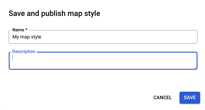
В правом верхнем углу выберите «Сохранить» .
В разделе «Сохранить и опубликовать стиль карты» введите название и, при желании, описание для вашего стиля карты.
Выберите «Сохранить» . Ваш стиль карты будет сохранен и опубликован.
Шаг 2: Создайте и подключите идентификатор карты.
Идентификатор карты позволяет использовать ваш стиль карты в приложениях и на веб-сайтах. Если вы вносите изменения в стиль карты, связанный с идентификатором карты, эти изменения вступают в силу при публикации, поэтому никаких обновлений программного обеспечения или приложений не требуется.
Создать идентификатор карты
В консоли Google Cloud выберите «Управление картами» .
Вверху выберите «Создать идентификатор карты» .

Добавьте название для идентификатора вашей карты и, при желании, описание.
Выберите тип карты для идентификатора карты в зависимости от того, где вы хотите использовать свой стиль карты.

Внизу страницы выберите «Сохранить» . Ваш идентификатор карты будет создан.
Свяжите идентификатор карты с вашим стилем карты.
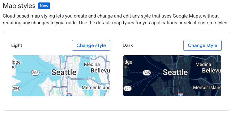
В разделе «Стили карты» выберите Изменить стиль режима освещения» для параметра «Режим освещения» .
В разделе «Изменить стиль освещения» выберите стиль карты, который будет использоваться в светлом режиме ваших приложений, и нажмите «Готово» .
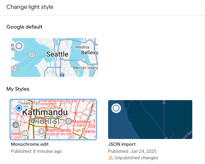
Выберите «Сохранить» . Теперь идентификатор вашей карты связан со стилями вашей карты.
Шаг 3: Добавьте идентификатор карты в свои приложения или веб-сайты.
Теперь, когда у вас есть идентификатор карты, связанный с опубликованным стилем карты, вы можете добавить его в свои приложения или веб-сайты и протестировать, чтобы убедиться, что он работает должным образом.
Для получения дополнительной информации о добавлении идентификатора карты см. раздел «Добавление идентификатора карты на карту» .
Что дальше?
Вот несколько вещей, которые вы можете попробовать в дальнейшем:
Обновить стиль . Чтобы внести изменения в стиль карты и опубликовать её, см. раздел «Изменение стиля» .
Поймите, как ваш стиль применяется к различным типам карт . Для получения дополнительной информации см. раздел «Узнайте о режимах и типах карт» .
Проверьте обновления стиля карты . Если вы хотите проверить изменения стиля перед их публикацией, см. раздел «Проверка обновлений стиля карты» .
Создавайте стили для конкретных уровней масштабирования . Например, вы можете настроить внешний вид определенных объектов карты при уменьшении масштаба по сравнению с увеличением масштаба. Для получения дополнительной информации см. раздел «Стиль уровней масштабирования» .
Используйте иерархию картографических объектов, чтобы эффективно получить нужные стили . Например, вы можете изменить стиль высокоуровневого картографического объекта «Природа > Земля» , и все расположенные под ним картографические объекты суши унаследуют этот стиль. Затем вы можете изменить стиль только тех дочерних картографических объектов, которые вы хотите выделить. Для получения дополнительной информации см. раздел «Понимание наследования и иерархии стилей карт» .