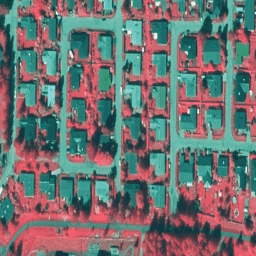
[[["わかりやすい","easyToUnderstand","thumb-up"],["問題の解決に役立った","solvedMyProblem","thumb-up"],["その他","otherUp","thumb-up"]],[["必要な情報がない","missingTheInformationINeed","thumb-down"],["複雑すぎる / 手順が多すぎる","tooComplicatedTooManySteps","thumb-down"],["最新ではない","outOfDate","thumb-down"],["翻訳に関する問題","translationIssue","thumb-down"],["サンプル / コードに問題がある","samplesCodeIssue","thumb-down"],["その他","otherDown","thumb-down"]],[],[[["\u003cp\u003eNLS Orthophotos are an aerial photo dataset covering all of Finland, provided by two agencies: Mavi (Agency for Rural Affairs) and SMK (The Energy Agency).\u003c/p\u003e\n"],["\u003cp\u003eOrthophotos are created by combining multiple aerial photographs to form a geographically accurate image.\u003c/p\u003e\n"],["\u003cp\u003eLatvia also offers Color InfraRed (CIR) orthophoto maps based on their national coordinate system, covering the entire country.\u003c/p\u003e\n"],["\u003cp\u003eThe orthophoto datasets for Finland and Latvia provide valuable resources for various applications due to their high resolution and comprehensive coverage.\u003c/p\u003e\n"]]],[],null,[]]