Datasets tagged districts in Earth Engine
Sử dụng bộ sưu tập để sắp xếp ngăn nắp các trang
Lưu và phân loại nội dung dựa trên lựa chọn ưu tiên của bạn.
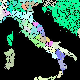
Phiên bản này của tập dữ liệu GAUL được đơn giản hoá ở mức 500 m. Global Administrative Unit Layers (GAUL) (Các lớp đơn vị hành chính toàn cầu) tổng hợp và phổ biến thông tin tốt nhất hiện có về các đơn vị hành chính cho tất cả các quốc gia trên thế giới, góp phần chuẩn hoá tập dữ liệu không gian đại diện cho các đơn vị hành chính. …
Global Administrative Unit Layers (GAUL) (Các lớp đơn vị hành chính toàn cầu) tổng hợp và phổ biến thông tin tốt nhất hiện có về các đơn vị hành chính cho tất cả các quốc gia trên thế giới, góp phần chuẩn hoá tập dữ liệu không gian đại diện cho các đơn vị hành chính. GAUL luôn duy trì các lớp toàn cầu với một lớp thống nhất…
[[["Dễ hiểu","easyToUnderstand","thumb-up"],["Giúp tôi giải quyết được vấn đề","solvedMyProblem","thumb-up"],["Khác","otherUp","thumb-up"]],[["Thiếu thông tin tôi cần","missingTheInformationINeed","thumb-down"],["Quá phức tạp/quá nhiều bước","tooComplicatedTooManySteps","thumb-down"],["Đã lỗi thời","outOfDate","thumb-down"],["Vấn đề về bản dịch","translationIssue","thumb-down"],["Vấn đề về mẫu/mã","samplesCodeIssue","thumb-down"],["Khác","otherDown","thumb-down"]],[],[],["The Global Administrative Unit Layers (GAUL) dataset compiles and disseminates information on administrative units for all countries, aiding in the standardization of spatial datasets representing these units. Two versions are available: GAUL 2015 (second-level units) and a simplified 500m version. Both provide global layers and are related to administrative borders, counties, and districts. These datasets are made available by the FAO.\n"]]