- データセットの利用可能な期間
- 2010-01-01T00:00:00Z–2010-01-02T00:00:00Z
- データセット プロデューサー
- 米国国勢調査局
- タグ
説明
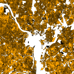
米国国勢調査局は、TIGER という名前のジオデータベースを定期的にリリースしています。このデータセットには、都市の 1 区画とほぼ同じ 2010 年の国勢調査ブロックが含まれています。米国、コロンビア特別区、プエルトリコ、島嶼部をカバーするポリゴン フィーチャーは 1,100 万件以上あります。
すべての TIGER 2010 プロダクトの技術的な詳細については、TIGER の技術ドキュメントをご覧ください。
テーブル スキーマ
テーブル スキーマ
| 名前 | 型 | 説明 |
|---|---|---|
| blockce | STRING | 2010 年国勢調査の集計ブロック番号 |
| blockid10 | STRING | ブロック識別子: 2010 年国勢調査の州の連邦情報処理標準(FIPS)コード、郡の FIPS コード、国勢調査区画コード、集計ブロック番号を連結したもの |
| countyfp10 | STRING | 郡の FIPS コード |
| housing10 | DOUBLE | 2010 年国勢調査の住宅戸数 |
| partflg | STRING | 部分ブロック フラグ |
| pop10 | DOUBLE | 2010 年国勢調査時点の総人口 |
| statefp10 | STRING | 2010 年国勢調査の州 FIPS コード |
| tractce10 | STRING | 2010 年国勢調査区コード |
利用規約
利用規約
米国国勢調査局は、一部の公開データをアプリケーション プログラミング インターフェース(API)を介して機械可読形式で提供しています。API を通じて提供されるすべてのコンテンツ、ドキュメント、コード、関連資料には、これらの利用規約が適用されます。
引用
引用:
データセットから作成されたレポート、出版物、新しいデータセット、派生商品、サービスについては、米国国勢調査局を引用する必要があります。
Earth Engine で探索する
コードエディタ(JavaScript)
var dataset = ee.FeatureCollection('TIGER/2010/Blocks');
var visParams = {
  min: 0,
  max: 700,
  palette: ['black', 'brown', 'yellow', 'orange', 'red']
};

// Turn the strings into numbers
dataset = dataset.map(function (f) {
  return f.set('pop10', ee.Number.parse(f.get('pop10')));
});

var image = ee.Image().float().paint(dataset, 'pop10');

Map.setCenter(-73.99172, 40.74101, 13);
Map.addLayer(image, visParams, 'TIGER/2010/Blocks');
Map.addLayer(dataset, null, 'for Inspector', false);
FeatureView として可視化する
FeatureView は、FeatureCollection の高速表示専用の表現です。詳細については、
FeatureView のドキュメントをご覧ください。
コードエディタ(JavaScript)
var fvLayer = ui.Map.FeatureViewLayer('TIGER/2010/Blocks_FeatureView');

var visParams = {
  opacity: 1,
  color: {
    property: 'pop10',
    mode: 'linear',
    palette: ['black', 'brown', 'yellow', 'orange', 'red'],
    min: 0,
    max: 700
  }
};

fvLayer.setVisParams(visParams);
fvLayer.setName('US census blocks');

Map.setCenter(-73.99172, 40.74101, 13);
Map.add(fvLayer);