Spain RGB orthophotos 10 cm
コレクションでコンテンツを整理
必要に応じて、コンテンツの保存と分類を行います。
- データセットの利用可能な期間
- 2007-01-01T00:00:00Z–2019-01-01T00:00:00Z
- データセット プロデューサー
-
スペインのオルソフォト
- Earth Engine スニペット
-
ee.ImageCollection("Spain/PNOA/PNOA10")
open_in_new
- タグ
-
orthophotos
rgb
pnoa
Spain
説明
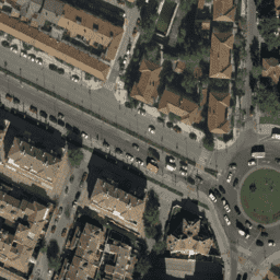
2007 年から 2018 年の間にさまざまな行政機関によって実施されたフライトのオルソフォトのモザイク。ピクセル解像度は 10 cm。このデータは、スペインの航空オルソフォトグラフィー国家計画(PNOA)から提供されています。
詳細については、スペインのオルソフォトのドキュメントをご覧ください。
バンド
ピクセルサイズ
0.1 メートル
バンド
| 名前 |
単位 |
最小 |
最大 |
ピクセルサイズ |
説明 |
R |
dn |
0
|
255
|
メートル |
赤 |
G |
dn |
0
|
255
|
メートル |
緑 |
B |
dn |
0
|
255
|
メートル |
青 |
利用規約
利用規約
データは無料で、正当な目的であれば自由に使用できます。唯一の厳格な義務は、国立地理院としてライセンス供与された地理情報プロダクトとサービスの出所と所有権を明示することです。
詳しくは、利用規約をご覧ください。
Earth Engine で探索する
コードエディタ(JavaScript)
var dataset = ee.ImageCollection('Spain/PNOA/PNOA10');
Map.setCenter(-1.859852, 38.983734, 19);
Map.addLayer(dataset, {}, 'Spain RGB (10cm)');
コードエディタで開く
[[["わかりやすい","easyToUnderstand","thumb-up"],["問題の解決に役立った","solvedMyProblem","thumb-up"],["その他","otherUp","thumb-up"]],[["必要な情報がない","missingTheInformationINeed","thumb-down"],["複雑すぎる / 手順が多すぎる","tooComplicatedTooManySteps","thumb-down"],["最新ではない","outOfDate","thumb-down"],["翻訳に関する問題","translationIssue","thumb-down"],["サンプル / コードに問題がある","samplesCodeIssue","thumb-down"],["その他","otherDown","thumb-down"]],[],[],[]]