- データセットの利用可能な期間
- 1950-01-01T00:00:00Z–2018-01-01T00:00:00Z
- データセット プロデューサー
- EnvirometriX Ltd
- タグ
説明
バンド
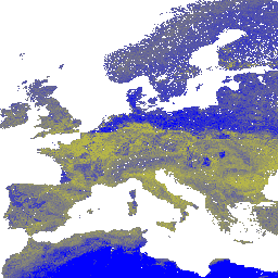
ピクセルサイズ
250 メートル
バンド
| 名前 | 単位 | 最小 | 最大 | ピクセルサイズ | 説明 |
|---|---|---|---|---|---|
b0 |
%(kg / kg) | 1* | 100* | メートル | 深さ 0 cm の砂の含有量 |
b10 |
%(kg / kg) | 1* | 100* | メートル | 深さ 10 cm の砂の含有量 |
b30 |
%(kg / kg) | 1* | 100* | メートル | 深さ 30 cm の砂の含有量 |
b60 |
%(kg / kg) | 1* | 100* | メートル | 深さ 60 cm の砂の含有量 |
b100 |
%(kg / kg) | 1* | 100* | メートル | 深さ 100 cm の砂の含有量 |
b200 |
%(kg / kg) | 1* | 100* | メートル | 深さ 200 cm の砂の含有量 |
利用規約
利用規約
引用
引用:
Tomislav Hengl 氏。(2018 年)、6 つの標準深度(0、10、30、60、100、200 cm)における砂の含有率(kg / kg)を 250 m の解像度で示す(バージョン v02)[データセット]。10.5281/zenodo.1476851
DOI
Earth Engine で探索する
コードエディタ(JavaScript)
var dataset = ee.Image('OpenLandMap/SOL/SOL_SAND-WFRACTION_USDA-3A1A1A_M/v02');

var visualization = {
  bands: ['b0'],
  min: 1.0,
  max: 100.0,
  palette: [
    'ffff00', 'f8f806', 'f1f10c', 'ebeb13', 'e4e419', 'dddd20',
    'd7d726', 'd0d02d', 'caca33', 'c3c33a', 'bcbc41', 'b6b647',
    'b0b04e', 'a9a954', 'a3a35a', '9c9c61', '959568', '8f8f6e',
    '898975', '82827b', '7b7b82', '757589', '6e6e8f', '686895',
    '61619c', '5a5aa3', '5454a9', '4d4db0', '4747b6', '4141bc',
    '3a3ac3', '3333ca', '2d2dd0', '2626d7', '2020dd', '1919e4',
    '1212eb', '0c0cf1', '0606f8', '0000ff',
  ]
};

Map.centerObject(dataset);

Map.addLayer(dataset, visualization, 'Sand content in % (kg / kg)');