- データセットの利用可能な期間
- 2000-02-18T00:00:00Z–2026-02-02T00:00:00Z
- データセット プロデューサー
- USGS EROS センターの NASA LP DAAC
- ケイデンス
- 16 日間
- タグ
説明
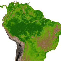
MOD13Q1 V6.1 プロダクトは、ピクセル単位で植生指数(VI)値を提供します。植生レイヤは主に 2 つあります。1 つ目は、正規化植生指標(NDVI)です。これは、既存の米国海洋大気庁 - 高度超高分解能放射計(NOAA-AVHRR)から導出された NDVI の連続性指標として参照されます。2 つ目の植生レイヤは、植生被覆の背景のばらつきを最小限に抑え、密度の高い植生条件での感度を維持する植生指標(EVI)です。EVI は、青色バンドを使用して、煙やサブピクセル薄雲によって生じた大気汚染の残留物も除去します。MODIS NDVI プロダクトと EVI プロダクトは、大気補正された双方向の地表反射率から計算されます。この反射率は、水、雲、高濃度のエアロゾル、雲の影でマスクされています。
ドキュメント:
バンド
ピクセルサイズ
250 メートル
バンド
| 名前 | 単位 | 最小 | 最大 | スケール | ピクセルサイズ | 波長 | 説明 | ||||||||||||||||||||||||||||||||||||||||||||||||||||||||||||||||||||||||||||||||||||||||||||
|---|---|---|---|---|---|---|---|---|---|---|---|---|---|---|---|---|---|---|---|---|---|---|---|---|---|---|---|---|---|---|---|---|---|---|---|---|---|---|---|---|---|---|---|---|---|---|---|---|---|---|---|---|---|---|---|---|---|---|---|---|---|---|---|---|---|---|---|---|---|---|---|---|---|---|---|---|---|---|---|---|---|---|---|---|---|---|---|---|---|---|---|---|---|---|---|---|---|---|---|
NDVI |
-2000 | 10,000 | 0.0001 | メートル | なし | 正規化植生指数 |
|||||||||||||||||||||||||||||||||||||||||||||||||||||||||||||||||||||||||||||||||||||||||||||
EVI |
-2000 | 10,000 | 0.0001 | メートル | なし | 強化された植生指数 |
|||||||||||||||||||||||||||||||||||||||||||||||||||||||||||||||||||||||||||||||||||||||||||||
DetailedQA |
メートル | なし | VI 品質指標 |
||||||||||||||||||||||||||||||||||||||||||||||||||||||||||||||||||||||||||||||||||||||||||||||||
sur_refl_b01 |
0 | 10,000 | 0.0001 | メートル | 645nm | 赤色の地表反射率 |
|||||||||||||||||||||||||||||||||||||||||||||||||||||||||||||||||||||||||||||||||||||||||||||
sur_refl_b02 |
0 | 10,000 | 0.0001 | メートル | 858nm | NIR 地表反射率 |
|||||||||||||||||||||||||||||||||||||||||||||||||||||||||||||||||||||||||||||||||||||||||||||
sur_refl_b03 |
0 | 10,000 | 0.0001 | メートル | 469nm | 青色の地表反射率 |
|||||||||||||||||||||||||||||||||||||||||||||||||||||||||||||||||||||||||||||||||||||||||||||
sur_refl_b07 |
0 | 10,000 | 0.0001 | メートル | 2130nm/2105 - 2155nm | MIR 地表反射率 |
|||||||||||||||||||||||||||||||||||||||||||||||||||||||||||||||||||||||||||||||||||||||||||||
ViewZenith |
度 | 0 | 18000 | 0.01 | メートル | なし | 天頂角を表示 |
||||||||||||||||||||||||||||||||||||||||||||||||||||||||||||||||||||||||||||||||||||||||||||
SolarZenith |
度 | 0 | 18000 | 0.01 | メートル | なし | 太陽天頂角 |
||||||||||||||||||||||||||||||||||||||||||||||||||||||||||||||||||||||||||||||||||||||||||||
RelativeAzimuth |
度 | -18000 | 18000 | 0.01 | メートル | なし | 相対方位角 |
||||||||||||||||||||||||||||||||||||||||||||||||||||||||||||||||||||||||||||||||||||||||||||
DayOfYear |
1 | 366 | メートル | なし | ユリウス通日 |
||||||||||||||||||||||||||||||||||||||||||||||||||||||||||||||||||||||||||||||||||||||||||||||
SummaryQA |
メートル | なし | VI ピクセルの品質の信頼性 |
||||||||||||||||||||||||||||||||||||||||||||||||||||||||||||||||||||||||||||||||||||||||||||||||
利用規約
利用規約
LP DAAC を通じて取得した MODIS データとプロダクトには、その後の使用、販売、再配布に関する制限はありません。
引用
引用:
LP DAAC データセットの引用については、LP DAAC の「Citing Our Data」ページを参照してください。
DOI
Earth Engine で探索する
コードエディタ(JavaScript)
var dataset = ee.ImageCollection('MODIS/061/MOD13Q1')
                  .filter(ee.Filter.date('2018-01-01', '2018-05-01'));
var ndvi = dataset.select('NDVI');
var ndviVis = {
  min: 0,
  max: 8000,
  palette: [
    'ffffff', 'ce7e45', 'df923d', 'f1b555', 'fcd163', '99b718', '74a901',
    '66a000', '529400', '3e8601', '207401', '056201', '004c00', '023b01',
    '012e01', '011d01', '011301'
  ],
};
Map.setCenter(6.746, 46.529, 2);
Map.addLayer(ndvi, ndviVis, 'NDVI');