- データセットの利用可能な期間
- 2000-02-18T00:00:00Z–2026-02-02T00:00:00Z
- データセット プロデューサー
- USGS EROS センターの NASA LP DAAC
- ケイデンス
- 16 日間
- タグ
説明
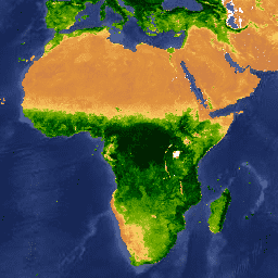
MOD13A2 V6.1 プロダクトは、正規化植生指数(NDVI)と拡張植生指数(EVI)の 2 つの植生指数(VI)を提供します。NDVI は、既存の米国海洋大気庁(NOAA)の AVHRR(Advanced Very High Resolution Radiometer)から導出された NDVI の継続性指標と呼ばれます。EVI は、バイオマスが多い地域で感度が向上しています。
このプロダクトのアルゴリズムは、16 日間のすべての獲得の中から、利用可能な最適なピクセル値を選択します。使用される条件は、低雲、低視角、最高の NDVI/EVI 値です。
ドキュメント:
バンド
ピクセルサイズ
1,000 メートル
バンド
| 名前 | 単位 | 最小 | 最大 | スケール | ピクセルサイズ | 波長 | 説明 | ||||||||||||||||||||||||||||||||||||||||||||||||||||||||||||||||||||||||||||||||||||||||||||
|---|---|---|---|---|---|---|---|---|---|---|---|---|---|---|---|---|---|---|---|---|---|---|---|---|---|---|---|---|---|---|---|---|---|---|---|---|---|---|---|---|---|---|---|---|---|---|---|---|---|---|---|---|---|---|---|---|---|---|---|---|---|---|---|---|---|---|---|---|---|---|---|---|---|---|---|---|---|---|---|---|---|---|---|---|---|---|---|---|---|---|---|---|---|---|---|---|---|---|---|
NDVI |
-2000 | 10,000 | 0.0001 | メートル | なし | 16 日間の NDVI 平均 |
|||||||||||||||||||||||||||||||||||||||||||||||||||||||||||||||||||||||||||||||||||||||||||||
EVI |
-2000 | 10,000 | 0.0001 | メートル | なし | 16 日間の EVI 平均 |
|||||||||||||||||||||||||||||||||||||||||||||||||||||||||||||||||||||||||||||||||||||||||||||
DetailedQA |
メートル | なし | VI 品質指標 |
||||||||||||||||||||||||||||||||||||||||||||||||||||||||||||||||||||||||||||||||||||||||||||||||
sur_refl_b01 |
0 | 10,000 | 0.0001 | メートル | 620 ~ 670 nm | バンド 1(赤)の地表反射率 |
|||||||||||||||||||||||||||||||||||||||||||||||||||||||||||||||||||||||||||||||||||||||||||||
sur_refl_b02 |
0 | 10,000 | 0.0001 | メートル | 841 ~ 876 nm | バンド 2 の地表反射率(近赤外線) |
|||||||||||||||||||||||||||||||||||||||||||||||||||||||||||||||||||||||||||||||||||||||||||||
sur_refl_b03 |
0 | 10,000 | 0.0001 | メートル | 459 ~ 479 nm | バンド 3(青)の地表反射率 |
|||||||||||||||||||||||||||||||||||||||||||||||||||||||||||||||||||||||||||||||||||||||||||||
sur_refl_b07 |
0 | 10,000 | 0.0001 | メートル | 2,105 ~ 2,155 nm | バンド 7 の地表反射率(中赤外) |
|||||||||||||||||||||||||||||||||||||||||||||||||||||||||||||||||||||||||||||||||||||||||||||
ViewZenith |
度 | 0 | 18000 | 0.01 | メートル | なし | VI ピクセルの天頂角を表示する |
||||||||||||||||||||||||||||||||||||||||||||||||||||||||||||||||||||||||||||||||||||||||||||
SolarZenith |
度 | 0 | 18000 | 0.01 | メートル | なし | VI ピクセルの太陽天頂角 |
||||||||||||||||||||||||||||||||||||||||||||||||||||||||||||||||||||||||||||||||||||||||||||
RelativeAzimuth |
度 | -18000 | 18000 | 0.01 | メートル | なし | VI ピクセルの相対方位角 |
||||||||||||||||||||||||||||||||||||||||||||||||||||||||||||||||||||||||||||||||||||||||||||
DayOfYear |
ユリウス日 | 1 | 366 | メートル | なし | 通日 VI ピクセル |
|||||||||||||||||||||||||||||||||||||||||||||||||||||||||||||||||||||||||||||||||||||||||||||
SummaryQA |
メートル | なし | VI ピクセルの品質の信頼性 |
||||||||||||||||||||||||||||||||||||||||||||||||||||||||||||||||||||||||||||||||||||||||||||||||
SummaryQA クラステーブル
| 値 | 色 | 説明 |
|---|---|---|
| 0 | なし | Good Data: 安心して使用できる |
| 1 | なし | 限界データ: 役立つが、他の QA 情報も確認する |
| 2 | なし | 雪氷: ターゲットが雪氷で覆われている |
| 3 | なし | 曇り: ターゲットが見えない、雲で覆われている |
利用規約
利用規約
LP DAAC を通じて取得した MODIS データとプロダクトには、その後の使用、販売、再配布に関する制限はありません。
引用
引用:
LP DAAC データセットの引用については、LP DAAC の「Citing Our Data」ページを参照してください。
DOI
Earth Engine で探索する
コードエディタ(JavaScript)
var dataset = ee.ImageCollection('MODIS/061/MOD13A2')
                  .filter(ee.Filter.date('2018-01-01', '2018-05-01'));
var ndvi = dataset.select('NDVI');
var ndviVis = {
  min: 0,
  max: 9000,
  palette: [
    'ffffff', 'ce7e45', 'df923d', 'f1b555', 'fcd163', '99b718', '74a901',
    '66a000', '529400', '3e8601', '207401', '056201', '004c00', '023b01',
    '012e01', '011d01', '011301'
  ],
};
Map.setCenter(6.746, 46.529, 2);
Map.addLayer(ndvi, ndviVis, 'NDVI');