-
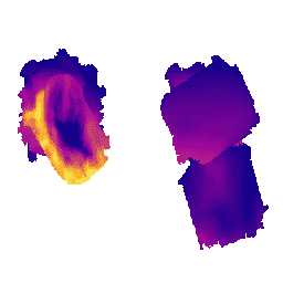
地球表面の鉱物性ダストの発生源調査 - メタンの増加
EMIT プロジェクトは、NASA 地球科学部門(ESD)のプログラム ディレクターが指揮する Earth Venture-Instrument(EV-I)プログラムの一部です。EMIT は、国際宇宙ステーション(ISS)への設置に適応された VSWIR 赤外線 Dyson イメージング分光計で構成されています。EMIT は放射輝度を測定します。 atmosphere daily emit methane nasa -
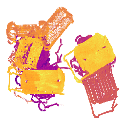
地球表面の鉱物性ダストの発生源調査 - メタン プルーム複合体
EMIT プロジェクトは、NASA 地球科学部門(ESD)のプログラム ディレクターが指揮する Earth Venture-Instrument(EV-I)プログラムの一部です。EMIT は、国際宇宙ステーション(ISS)への設置に適応された VSWIR 赤外線 Dyson イメージング分光計で構成されています。EMIT は放射輝度を測定します。 atmosphere daily emit methane nasa -
MethaneAIR L3 Concentration v1
このデータセットは、MethaneAIR イメージング分光計で観測された大気中のメタンの全カラム乾燥空気モル分率「XCH4」の地理空間データを提供します。XCH4 は、メタン(「CH4」)の総カラム量(分子数)を総量で割った値として定義されます。 atmosphere climate edf emissions ghg methane -
MethaneAIR L4 Area Sources v1
この地域の排出量モデルはまだ開発中であり、最終製品を表すものではありません。このデータセットは、米国全土の石油とガスの生産地域に焦点を当てた MethaneAIR 飛行の測定値を使用して、空間的に分解されたメタン排出フラックス(kg/時)を提供します。アンケートの総排出量… atmosphere climate edf emissions ghg methane -
MethaneAIR L4 Point Sources v1

このデータセットは、西部のコロラド州、ニューメキシコ州、テキサス州から東部のペンシルベニア州、オハイオ州、ウェストバージニア州までの 13 の石油、ガス、石炭の採掘地域と、3 つの都市部(ニューヨーク市、…)における、メタン排出量の多いポイント ソースの検出データ(kg/時)を提供します。 atmosphere climate edf emissions ghg methane -
MethaneSAT L3 濃度パブリック プレビュー V1.0.0
この早期の「一般公開プレビュー」データセットは、MethaneSAT イメージング分光計による測定から取得された、大気中のメタンの柱平均乾燥空気モル分率「XCH4」の地理空間データを提供します。XCH4 は、… の総カラム量(単位表面積あたりの分子数)として定義されます。 atmosphere climate edf edf-methanesat-ee emissions ghg -
MethaneSAT L4 Area Sources パブリック プレビュー V1.0.0
分散エリア排出量モデルはまだ開発中であり、最終製品を表すものではありません。この早期の「公開プレビュー」データセットは、分散型エリアソースからのメタン排出量に関する高精度のデータを提供します。これらの排出量データは、… のアパラチア、ペルミアン、ユインタの各盆地から取得されています。 atmosphere climate edf edf-methanesat-ee emissions ghg -
MethaneSAT L4 Area Sources パブリック プレビュー V2.0.0

分散エリア排出量モデルはまだ開発中であり、最終製品を表すものではありません。この早期の「公開プレビュー」データセットは、分散型エリアソースからのメタン排出量に関する高精度のデータを提供します。これらの新しい測定により、総メタン排出量を高精度で定量化することの重要性が示されています。 atmosphere climate edf edf-methanesat-ee emissions ghg -
MethaneSAT L4 ポイント ソースの一般提供プレビュー版 V1.0.0

この早期の「一般公開プレビュー」データセットは、個別のポイント ソースからのメタン排出量に関する高精度のデータを提供します。これらのメタン排出フラックスは、… の高い空間解像度、広い空間範囲、高精度を活用するために特化した点源検出と排出量定量化フレームワークを使用して生成されました。 atmosphere climate edf edf-methanesat-ee emissions ghg -
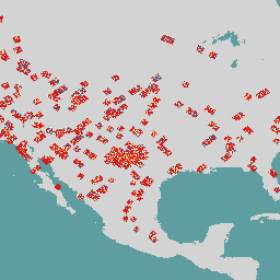
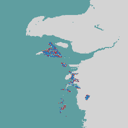
OGIM: Oil and Gas Infrastructure Mapping Database v2.5.1
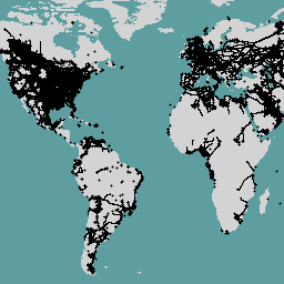
このデータセットは、世界中の石油ガス(O&G)関連インフラストラクチャの場所を提供します。石油・ガス インフラストラクチャ マッピング(OGIM)データベースは、環境防衛基金(EDF)と EDF の完全子会社である MethaneSAT LLC が開発したプロジェクトです。… を開発する主な目的は、 edf emissions ghg infrastructure-boundaries methane methaneair -
Sentinel-5P OFFL CH4: オフライン メタン
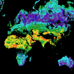
OFFL/L3_CH4: このデータセットは、メタン濃度のオフライン高解像度画像を提供します。メタン(CH4)は、二酸化炭素(CO2)に次いで、人為的に強化された温室効果の 2 番目に重要な原因となっています。メタン排出量の約 4 分の 3 は人為的なものであり、衛星ベースの測定記録を継続することが重要です。 atmosphere climate copernicus esa eu knmi