-
CSP gHM: Global Human Modification(グローバルな人間の変更)
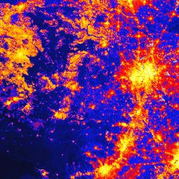
グローバルな人間による改変データセット(gHM)は、地球上の陸地の人間による改変の累積的な測定値を 1 平方キロメートルの解像度で提供します。gHM 値は 0.0 ~ 1.0 の範囲で、特定の場所(ピクセル)が変更された割合、推定強度などを推定して計算されます。 csp fragmentation human-modification landcover landscape-gradient population -
Global ALOS CHILI(Continuous Heat-Insolation Load Index)

CHILI は、正午直後の日射量と、春分の日相当の太陽高度を計算することで表される、日射量と地形の陰影が蒸発散に及ぼす影響の代用となります。これは、JAXA の ALOS DEM の 30 m の「AVE」バンド(EE で JAXA/ALOS/AW3D30_V1_1 として利用可能)に基づいています。The Conservation Science … aspect csp elevation elevation-topography ergo geophysical -
Global ALOS Landforms

ALOS Landform データセットは、連続日射量負荷指数(ALOS CHILI)とマルチスケール地形位置指数(ALOS mTPI)のデータセットを組み合わせて作成された地形クラスを提供します。これは、JAXA の ALOS DEM の 30 m の「AVE」バンド(EE で JAXA/ALOS/AW3D30_V1_1 として利用可能)に基づいています。Conservation … aspect csp elevation elevation-topography ergo geophysical -
Global ALOS Topographic Diversity

地形の多様性(D)は、種が局所的な生息地として利用できる温度と湿度の条件の多様性を表す代理変数です。これは、地形気候ニッチの多様性が高いほど、多様性(特に植物)が高くなり、気候変動を考慮した種の存続がサポートされるというロジックを表しています。 aspect csp elevation elevation-topography ergo geophysical -
Global ALOS mTPI(マルチスケール地形位置指数)

mTPI は、尾根と谷の形状を区別します。各位置の標高データから近隣の平均標高を差し引いて計算されます。mTPI は、半径(km)が 115.8、89.9、35.5、13.1、5.6、2.8、1.2 の移動ウィンドウを使用します。これは 30 分間の … aspect csp elevation elevation-topography ergo geophysical -
Global SRTM CHILI(Continuous Heat-Insolation Load Index)

CHILI は、正午直後の日射量と、春分の日相当の太陽高度を計算することで表される、日射量と地形の陰影が蒸発散に及ぼす影響の代用となります。これは 30 m の SRTM DEM(EE では USGS/SRTMGL1_003 として利用可能)に基づいています。Conservation Science Partners(CSP)の生態学的に関連性の高い… aspect csp elevation elevation-topography ergo geophysical -
Global SRTM Landforms

SRTM Landform データセットは、連続日射量負荷指数(SRTM CHILI)とマルチスケール地形位置指数(SRTM mTPI)のデータセットを組み合わせて作成された地形クラスを提供します。これは 30 m の SRTM DEM(EE では USGS/SRTMGL1_003 として利用可能)に基づいています。Conservation Science Partners(CSP)の生態学的に… aspect csp elevation elevation-topography ergo geophysical -
Global SRTM Topographic Diversity

地形の多様性(D)は、種が局所的な生息地として利用できる温度と湿度の条件の多様性を表す代理変数です。これは、地形気候ニッチの多様性が高いほど、多様性(特に植物)が高くなり、気候変動を考慮した種の存続がサポートされるというロジックを表しています。 aspect csp elevation elevation-topography ergo geophysical -
グローバル SRTM mTPI(マルチスケール地形位置指数)

mTPI は、尾根と谷の形状を区別します。各位置の標高データから近隣の平均標高を差し引いて計算されます。mTPI は、半径(km)が 115.8、89.9、35.5、13.1、5.6、2.8、1.2 の移動ウィンドウを使用します。これは 30 分間の … aspect csp elevation elevation-topography ergo geophysical -
US Lithology

岩相データセットは、地表の土壌の母材の一般的な種類のクラスを提供します。DEM から派生したものではありません。Conservation Science Partners(CSP)の Ecologically Relevant Geomorphology(ERGo)データセット、地形、地形学には、地形と地形学に関する詳細なマルチスケール データが含まれています。 aspect csp elevation elevation-topography ergo geophysical -
US NED CHILI(連続日射負荷指数)

CHILI は、正午直後の日射量と、春分の日相当の太陽高度を計算することで表される、日射量と地形の陰影が蒸発散に及ぼす影響の代用となります。これは USGS の 10m NED DEM(EE で USGS/NED として利用可能)に基づいています。Conservation Science Partners(CSP)の生態学的に… aspect csp elevation elevation-topography ergo geophysical -
US NED Landforms

ALOS Landform データセットは、Continuous Heat-Insolation Load Index(CHILI)とマルチスケール Topographic Position Index(mTPI)のデータセットを組み合わせて作成された地形クラスを提供します。これは USGS の 10m NED DEM(EE で USGS/NED として利用可能)に基づいています。Conservation Science Partners(CSP)の生態学的に関連性の高い… aspect csp elevation elevation-topography ergo geophysical -
米国の NED 地形多様性

Physiographic Diversity データセットは、地形多様性指数のデータを提供します。これは、複数のスケール(km)でシャノン多様性指数を使用して計算されました。115.8、89.9、35.5、13.1、5.6、2.8、1.2。これは、USGS の 10 m NED DEM(EE で利用可能)に基づいています。 aspect csp elevation elevation-topography ergo geophysical -
米国の NED 地形多様性

地形の多様性(D)は、種が局所的な生息地として利用できる温度と湿度の条件の多様性を表す代理変数です。これは、地形気候ニッチの多様性が高いほど、多様性(特に植物)が高くなり、気候変動を考慮した種の存続がサポートされるというロジックを表しています。 aspect csp elevation elevation-topography ergo geophysical -
US NED mTPI(マルチスケール地形位置指数)

mTPI は、尾根と谷の形状を区別します。各位置の標高データから近隣の平均標高を差し引いて計算されます。mTPI は、半径(km)が 115.8、89.9、35.5、13.1、5.6、2.8、1.2 の移動ウィンドウを使用します。これは、USGS の … に基づいています。 aspect csp elevation elevation-topography ergo geophysical -
米国の地形

地形データセットは、地形(EE では ERGo/1_0/US/landforms として利用可能)と岩相(EE では ERGo/1_0/US/lithology として利用可能)のデータレイヤの空間的交差を表します。270 通りの組み合わせのうち、247 通りの組み合わせが可能です。各タイプの値は、地形と…を連結して形成されます。 aspect csp elevation elevation-topography ergo geophysical