- カタログ オーナー
- Awesome GEE Community Catalog
- データセットの利用可能な期間
- 2022-01-26T00:00:00Z–2022-01-26T23:59:00Z
- データセット プロデューサー
- Bahram Khazaei
- タグ
説明
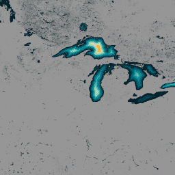
140 万を超える世界の水域に関するデータを含む GLObal Bathymetric(GLOBathy)データセットは、広く認識されている HydroLAKES データセットと調和するように綿密に開発されています。高度な地理情報システム(GIS)ベースのフレームワークを利用して、GLOBathy は HydroLAKES から取得した最大水深の推定値と幾何学的/物理学的属性を統合し、詳細な水深図を作成します。データの正確性と信頼性を確保するため、GLOBathy は 1,503 の水域とさまざまな観測データソースを含む厳格な検証手順を実施しています。その結果、GLOBathy は水路学と水生科学のための堅牢で包括的なデータセットとなり、これらの分野の研究者や専門家にとって貴重なリソースとなっています。
バンド
ピクセルサイズ
30 メートル
バンド
| 名前 | 単位 | 最小 | 最大 | ピクセルサイズ | 説明 |
|---|---|---|---|---|---|
b1 |
m | 0* | 1548.53* | メートル | 最大深度 |
利用規約
利用規約
このデータセットは、CC0 1.0 Universal(CC0 1.0)Public Domain Dedication の下でリリースされます。このデータセットの生成と資金調達を担当する組織は、商品性や特定の用途への適合性の保証などを含むいかなる種類の表明も行いません。また、データに関してそのような保証が黙示的に行われることもありません。
引用
引用:
Khazaei, Bahram; Read, Laura K; Casali, Matthew; Sampson, Kevin M; Yates, David N(2022): GLOBathy Bathymetry Rasters。figshare。Dataset. https://doi.org/10.6084/m9.figshare.c.5243309.v1
DOI
Earth Engine で探索する
コードエディタ(JavaScript)
var globathy = ee.Image(
  "projects/sat-io/open-datasets/GLOBathy/GLOBathy_bathymetry"
);

var palettes = require("users/samapriya/utils:palettes");

// Use these visualization parameters, customized by location.
var visParams = { min: 1, max: 700, palette: palettes.extra.blkred };

// Note that the visualization image doesn't require visualization parameters.
Map.addLayer(globathy, visParams, "Globathy Bathymetry (m)");