- Catalog Owner
- National Ecological Observatory Network
- Dataset Availability
- 2013-01-01T00:00:00Z–2024-09-04T14:45:01Z
- Dataset Provider
- NEON
- Earth Engine Snippet
-
ee.ImageCollection("projects/neon-prod-earthengine/assets/CHM/001")
- Tags
Description
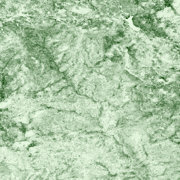
Height of the top of canopy above bare earth (Canopy Height Model; CHM). The CHM is derived from the LiDAR point cloud and is generated by creating a continuous surface of canopy height estimates across the entire spatial domain of the LiDAR survey. The point cloud is separated into classes representing the ground and vegetation returns. The ground classified points are used to generate a height-normalized point cloud that provides a relative estimate of vegetation elevation. A surface is then generated using the height normalized vegetation points to produce the CHM. Any canopy heights less than 2 m are set to zero for data collected with the Optech Gemini LiDAR sensors, and less than 2/3 m for the Riegl and Optech Galaxy sensors. Data are mosaicked over the AOP footprint onto a spatially uniform grid at 1 m spatial resolution.
See NEON Data Product DP3.30015.001 for more details.
Documentation: NEON Ecosystem structure (DP3.30015.001) Quick StartGuide
Get started by exploring the Intro to AOP Data in Google Earth Engine Tutorial Series
Browse and interact with AOP data in the NEON AOP GEE Data Viewer App
Bands
Pixel Size
1 meter
Bands
| Name | Units | Min | Max | Description |
|---|---|---|---|---|
CHM |
m | 0 | 100 | Canopy Height Model |
Image Properties
Image Properties
| Name | Type | Description |
|---|---|---|
| AOP_VISIT_NUMBER | INT | Unique visit number to the NEON site. |
| CITATION | STRING | Data citation. See NEON Data Policies and Citation Guidelines. |
| DOI | STRING | Digital Object Identifier. NEON data that have been released are assigned a DOI. |
| FLIGHT_YEAR | INT | Year the data were collected |
| NEON_DOMAIN | STRING | NEON eco-climatic domain code, "D01" to "D20". See NEON Field Sites and Domains. |
| NEON_SITE | STRING | NEON four-digit site code. See NEON Field Sites. |
| NEON_SITE_NAME | STRING | Full name of the NEON site. See NEON Field Sites. |
| NEON_DATA_PROD_URL | STRING | NEON data product url. Always set to: https://data.neonscience.org/data-products/DP3.30015.001. |
| SENSOR_NAME | STRING | Make and model of the lidar sensor: "Optech Galaxy Prime", "Optech Gemini", "Riegl Q780". |
| SENSOR_SERIAL | STRING | Serial number of the lidar sensor: "11SEN287", "12SEN311", "5060445", "220855". |
| PROVISIONAL_RELEASED | STRING | Whether the data are Provisional or Released. See https://www.neonscience.org/data-samples/data-management/data-revisions-releases. |
| RELEASE_YEAR | INT | If data are released, the year of the NEON Release Tag. |
Terms of Use
Terms of Use
All data collected by NEON and provided as data products, with the exception of data related to rare, threatened, or endangered (RTE) species, are released to the public domain under Creative Commons CC0 1.0 "No Rights Reserved". No copyright has been applied to NEON data; any person may copy, modify, or distribute the data, for commercial or non-commercial purposes, without asking for permission. NEON data may still be subject to other laws or rights such as for privacy, and NEON makes no warranties about the data and disclaims all liability. When using or citing NEON data, no implication should be made about endorsement by NEON. In most countries, data and facts are not copyrightable. By putting NEON data into the public domain, we encourage broad use, particularly in scientific analyses and data aggregations. However, please be aware of the following scholarly norms: NEON data should be used in a way that is mindful of the limitations of the data, using the documentation associated with the data packages as a guide. Please refer to NEON Data Guidelines and Policies for detailed information on how to properly use and cite NEON data, as well as best practices for publishing research that uses NEON data.
Citations
Explore with Earth Engine
Code Editor (JavaScript)
// Read in the NEON AOP CHM Image Collection
var chm = ee.ImageCollection(
  'projects/neon-prod-earthengine/assets/CHM/001');

// Display available images in the CHM Image Collection
print('NEON CHM Images', chm.aggregate_array('system:index'))

// Specify the start and end dates and filter by dates
var startDate = ee.Date('2021-01-01');
var endDate = startDate.advance(1, 'year');
var chm2021 = chm.filterDate(startDate, endDate);

// Filter by NEON site name (see https://www.neonscience.org/field-sites/explore-field-sites)
var soapCHM = chm2021.filter('NEON_SITE == "SOAP"');

// Define the visualization parameters, using a green color palette
var chmVis = {min: 0, max: 35, palette: ['E6F7E0', '063B00']};

// Add the CHM layer to the Map and center on the site
Map.addLayer(soapCHM, chmVis, 'SOAP 2021 Canopy Height Model (m)');
Map.setCenter(-119.25, 37.06, 12);