- データセットの利用可能な期間
- 2003-01-01T00:00:00Z–2018-12-31T00:00:00Z
- データセット プロデューサー
- Yale Center for Earth Observation(YCEO)
- タグ
説明
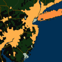
このデータセットには、世界中の 10,000 を超える都市クラスタの昼と夜の年間、夏季、冬季の地表都市ヒートアイランド(SUHI)強度が含まれています。このデータセットは、MODIS 8 日間の TERRA および AQUA 地表温度(LST)プロダクト、Landscan 都市範囲データベース、Global Multi-resolution Terrain Elevation Data 2010、European Space Agency(ESA)Climate Change Initiative(CCI)土地被覆データを使用して、Simplified Urban-Extent Algorithm を使用して作成されました。このプロダクトは、ピクセルレベル(ダウンスケーリング後の解像度は 300 m)と、2003 年から 2018 年までの都市クラスターの平均値の両方で利用できます。月単位の複合データは、都市クラスターの平均値としてのみ利用できます。
最初に公開された原稿で作成および分析されたデータセットからの変更を含む、以前のバージョンの概要については、イェール大学地球観測センターのウェブサイトをご覧ください。データセットは、Global Surface UHI Explorer ウェブ アプリケーションを使用して探索することもできます。
データセットは次の 6 つのコンポーネントに分割されます。
UHI_all_averaged: 年間、夏、冬のクラスタ平均の昼間と夜間の SUHI 強度を合成した画像。
UHI_monthly_averaged: 昼間と夜間の SUHI 強度のクラスタ平均月次合成を含む画像。
UHI_yearly_averaged: 2003 年から 2018 年までの昼間と夜間の SUHI 強度のクラスタ平均年次複合画像のコレクション。
UHI_yearly_pixel: 2003 年から 2018 年までの空間的に分解された(名義尺度 300 m)年間の昼間と夜間の SUHI 強度の画像コレクション。
Summer_UHI_yearly_pixel: 2003 年から 2018 年までの夏の昼間と夜間の SUHI 強度を空間的に分解した(名義尺度 300 m)画像コレクション。
Winter_UHI_yearly_pixel: 2003 年から 2018 年までの冬の昼間と夜間の SUHI 強度を空間的に分解した(名義尺度 300 m)画像コレクション。
このアセットは 3 番目のコンポーネントです。
バンド
ピクセルサイズ
300 メートル
バンド
| 名前 | 単位 | ピクセルサイズ | 説明 |
|---|---|---|---|
Daytime |
°C | メートル | 日中の UHI |
Nighttime |
°C | メートル | 夜間のヒートアイランド現象 |
利用規約
利用規約
引用
Chakraborty, T.、& Lee, X. (2019 年)都市部の地表熱アイランドをグローバル スケールで特徴づけ、その時空間変動に対する植生制御を調べるための、簡略化された都市部拡大アルゴリズム。International Journal of Applied Earth Observation and Geoinformation、74、269-280。 doi:10.1016/j.jag.2018.09.015
Earth Engine で探索する
コードエディタ(JavaScript)
var dataset = ee.ImageCollection('YALE/YCEO/UHI/UHI_yearly_averaged/v4');

var visualization = {
  bands: ['Daytime'],
  min: -1.5,
  max: 7.5,
  palette: [
    '313695', '74add1', 'fed976', 'feb24c','fd8d3c', 'fc4e2a', 'e31a1c',
    'b10026']
};

Map.setCenter(-74.7, 40.6, 7);

Map.addLayer(dataset, visualization, 'Daytime UHI');