- データセットの利用可能な期間
- 2018-01-01T00:00:00Z–2019-01-01T00:00:00Z
- データセット プロデューサー
- 清華大学地球システム科学学部(DESS、THU)
- タグ
説明
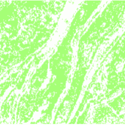
このデータセットは、2018 年の中国の棚田地図(解像度 30 m)です。このモデルは、Google Earth Engine プラットフォームに基づいて、マルチソースおよびマルチテンポラル データを使用した教師ありピクセルベースの分類を通じて開発されました。全体的な精度とカッパ係数はそれぞれ 94% と 0.72 を達成しました。この最初の 30 m 中国段々畑地図は、土壌浸食、食料安全保障、生物地球化学的循環、生物多様性、生態系サービスの評価に関する研究に使用できます。
バンド
バンド
| 名前 | ピクセルサイズ | 説明 |
|---|---|---|
terrace |
30 メートル | テラスがある場合は 1、ない場合は 0。 |
テラス クラス テーブル
| 値 | 色 | 説明 |
|---|---|---|
| 0 | #ffffff | テラスなし |
| 1 | #a3ff74 | テラスがある |
利用規約
利用規約
引用
引用:
Cao, B.、Yu, L.、Naipal, V.、Ciais, P.、Li, W.、Zhao, Y.、Wei, W.、Chen, D.、Liu, Z.、Gong, P.: Google Earth Engine に基づく Landsat 8 画像とデジタル標高モデルを使用した中国の 30 m の段丘マッピング、Earth Syst. Sci. Data, 13, 2437-2456, doi:10.5194/essd-13-2437-2021, 2021.
DOI
Earth Engine で探索する
コードエディタ(JavaScript)
var image = ee.Image('Tsinghua/DESS/ChinaTerraceMap/v1');

var image = image.updateMask(image);
Map.addLayer(image, {min: 0, max: 1, palette: ['a3ff74']}, 'Terraces');

Map.setCenter(106.6, 30.4, 10);
Map.setOptions('SATELLITE');