- データセットの利用可能な期間
- 2014-01-01T00:00:00Z–2026-02-19T00:00:00Z
- データセット プロデューサー
- NOAA
- ケイデンス
- 1 日
- タグ
説明
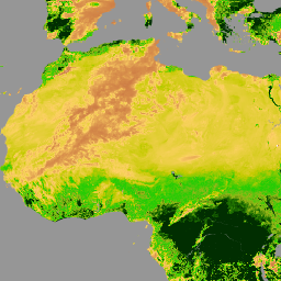
このデータセットには、NOAA の可視赤外線画像放射計スイート(VIIRS)表面反射率の気候データ記録(CDR)から導出された、グリッド化された毎日の正規化植生指数(NDVI)が含まれています。データレコードは、NOAA の極軌道衛星のデータを使用して 2014 年以降にわたっています。データは 0.05 度 x 0.05 度のグローバル グリッドに投影されます。このデータセットは、NASA ゴダード宇宙飛行センター(GSFC)とメリーランド大学(UMD)が作成した陸地表面 CDR プロダクトの 1 つです。
このデータセットに関する既知の問題は次のとおりです。
TIMEOFDAY 変数に 1 日分大きすぎる値が含まれている
緯度の値がグリッド セルの中心に正しく関連付けられていない。誤差は 0.002 度未満
経度の値がグリッド セルの中心に正しく関連付けられていない。誤差は 0.02 度未満
データ プロバイダからの技術メモをご覧ください。
プロバイダの注: N-19(AVHRR センサーを搭載した最後の NOAA 衛星)の軌道ドリフトにより、取得されたプロダクトの品質が著しく低下し始めました。そのため、2014 年から現在まで、これらのプロダクトで使用されている主なセンサーは VIIRS です。
バンド
ピクセルサイズ
5,566 メートル
バンド
| 名前 | 単位 | 最小 | 最大 | スケール | ピクセルサイズ | 説明 | |||||||||||||||||||||||||||||||||||||||||||||||||||||||||||||||||||||||||||||||||||||||||||||
|---|---|---|---|---|---|---|---|---|---|---|---|---|---|---|---|---|---|---|---|---|---|---|---|---|---|---|---|---|---|---|---|---|---|---|---|---|---|---|---|---|---|---|---|---|---|---|---|---|---|---|---|---|---|---|---|---|---|---|---|---|---|---|---|---|---|---|---|---|---|---|---|---|---|---|---|---|---|---|---|---|---|---|---|---|---|---|---|---|---|---|---|---|---|---|---|---|---|---|---|
NDVI |
-9998* | 9998* | 0.0001 | メートル | 正規化植生指数 |
||||||||||||||||||||||||||||||||||||||||||||||||||||||||||||||||||||||||||||||||||||||||||||||
TIMEOFDAY |
h | 0* | 2400* | 0.01 | メートル | 1 日の開始からの時間数 |
|||||||||||||||||||||||||||||||||||||||||||||||||||||||||||||||||||||||||||||||||||||||||||||
QA |
メートル | 品質管理ビットフラグ |
|||||||||||||||||||||||||||||||||||||||||||||||||||||||||||||||||||||||||||||||||||||||||||||||||
画像プロパティ
画像プロパティ
| 名前 | 型 | 説明 |
|---|---|---|
| ステータス | STRING | 「provisional」または「permanent」 |
利用規約
利用規約
NOAA CDR プログラムの CDR の公式配布ポイントは NOAA の国立気候データ センターです。このセンターは、米国の大統領の「オープンデータ ポリシー」に関する覚書に記載され、2013 年 5 月 9 日の「政府情報のオープン化と機械可読化を新たなデフォルトとする」大統領令に準拠して、CDR パッケージと関連情報の持続的でオープンなアクセスとアクティブなデータ管理を提供しています。これらのポリシーに沿って、CDR データセットは非独占的で、一般公開されており、その使用に制限はありません。詳細については、NOAA の CDR データセット、アルゴリズム、ドキュメントのフェアユースの PDF をご覧ください。
引用
引用元: Vermote, Eric; NOAA CDR Program。(2022 年): NOAA Climate Data Record(CDR)of VIIRS Normalized Difference Vegetation Index(NDVI)、バージョン 1。[indicate subset used]。NOAA National Centers for Environmental Information. https://doi.org/10.25921/gakh-st76
DOI
Earth Engine で探索する
コードエディタ(JavaScript)
var dataset = ee.ImageCollection('NOAA/CDR/VIIRS/NDVI/V1')
                  .filter(ee.Filter.date('2018-05-01', '2018-06-01'));
var ndvi = dataset.select('NDVI');
var ndviVis = {
  min: -1000.0,
  max: 5000.0,
  palette: [
    'ffffff', 'ce7e45', 'fcd163', 'c6ca02', '22cc04', '99b718', '207401',
    '012e01'
  ],
};
Map.setCenter(7.71, 17.93, 2);
Map.addLayer(ndvi, ndviVis, 'NDVI');