- データセットの利用可能な期間
- 2000-02-24T00:00:00Z–2023-02-17T00:00:00Z
- データセット プロデューサー
- ケイデンス
- 1 日
- タグ
説明
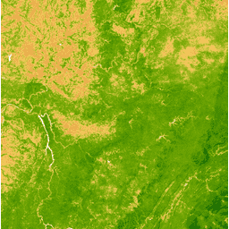
植生指標(EVI)は、各シーンの近赤外、赤、青のバンドから生成され、値の範囲は -1.0 ~ 1.0 です。詳しくは、Huete et al.(2002 年)をご覧ください。このプロダクトは、MODIS/006/MOD09GA 地表反射率コンポジットから生成されます。
バンド
バンド
| 名前 | ピクセルサイズ | 説明 |
|---|---|---|
EVI |
463.313 メートル | 強化された植生指数 |
利用規約
利用規約
LP DAAC を通じて取得した MODIS データとプロダクトには、その後の使用、販売、再配布に関する制限はありません。
Earth Engine で探索する
コードエディタ(JavaScript)
var dataset = ee.ImageCollection('MODIS/MOD09GA_006_EVI')
                  .filter(ee.Filter.date('2018-04-01', '2018-06-01'));
var colorized = dataset.select('EVI');
var colorizedVis = {
  min: 0,
  max: 1,
  palette: [
    'ffffff', 'ce7e45', 'df923d', 'f1b555', 'fcd163', '99b718', '74a901',
    '66a000', '529400', '3e8601', '207401', '056201', '004c00', '023b01',
    '012e01', '011d01', '011301'
  ],
};
Map.setCenter(-7.03125, 31.0529339857, 2);
Map.addLayer(colorized, colorizedVis, 'Colorized');