- データセットの利用可能な期間
- 2002-07-04T00:00:00Z–2026-02-20T00:00:00Z
- データセット プロデューサー
- USGS EROS センターの NASA LP DAAC
- ケイデンス
- 1 日
- タグ
説明
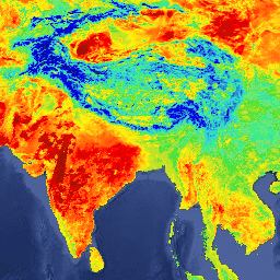
MYD11A1 V6.1 プロダクトは、1,200 x 1,200 キロメートルのグリッドで毎日の地表面温度(LST)と放射率の値を提供します。温度値は MYD11_L2 スワス プロダクトから取得されます。緯度 30 度を超えると、晴天の条件を満たす複数の観測値を持つピクセルが存在する可能性があります。この場合、ピクセル値は、条件を満たすすべての観測値の平均値になります。昼間と夜間の地表温度帯とその品質指標レイヤとともに、MODIS バンド 31 と 32、6 つの観測レイヤが提供されます。
ドキュメント:
バンド
ピクセルサイズ
1,000 メートル
バンド
| 名前 | 単位 | 最小 | 最大 | スケール | オフセット | ピクセルサイズ | 説明 | ||||||||||||||||||||||||||||||||||||||||||||||||||||||||||||||||||||||||||||||||||||||||||||
|---|---|---|---|---|---|---|---|---|---|---|---|---|---|---|---|---|---|---|---|---|---|---|---|---|---|---|---|---|---|---|---|---|---|---|---|---|---|---|---|---|---|---|---|---|---|---|---|---|---|---|---|---|---|---|---|---|---|---|---|---|---|---|---|---|---|---|---|---|---|---|---|---|---|---|---|---|---|---|---|---|---|---|---|---|---|---|---|---|---|---|---|---|---|---|---|---|---|---|---|
LST_Day_1km |
K | 7500 | 65535 | 0.02 | メートル | 日中の地表温度 |
|||||||||||||||||||||||||||||||||||||||||||||||||||||||||||||||||||||||||||||||||||||||||||||
QC_Day |
メートル | 昼間の LST 品質指標 |
|||||||||||||||||||||||||||||||||||||||||||||||||||||||||||||||||||||||||||||||||||||||||||||||||
Day_view_time |
h | 0 | 240 | 0.1 | メートル | ローカルの時刻の観測 |
|||||||||||||||||||||||||||||||||||||||||||||||||||||||||||||||||||||||||||||||||||||||||||||
Day_view_angle |
度 | 0 | 130 | -65 | メートル | 日中の観測の天頂角を表示する |
|||||||||||||||||||||||||||||||||||||||||||||||||||||||||||||||||||||||||||||||||||||||||||||
LST_Night_1km |
K | 7500 | 65535 | 0.02 | メートル | 夜間の地表温度 |
|||||||||||||||||||||||||||||||||||||||||||||||||||||||||||||||||||||||||||||||||||||||||||||
QC_Night |
メートル | 夜間の LST 品質指標 |
|||||||||||||||||||||||||||||||||||||||||||||||||||||||||||||||||||||||||||||||||||||||||||||||||
Night_view_time |
h | 0 | 240 | 0.1 | メートル | 夜間観測の現地時間 |
|||||||||||||||||||||||||||||||||||||||||||||||||||||||||||||||||||||||||||||||||||||||||||||
Night_view_angle |
度 | 0 | 130 | -65 | メートル | 夜間観測の天頂角を表示する |
|||||||||||||||||||||||||||||||||||||||||||||||||||||||||||||||||||||||||||||||||||||||||||||
Emis_31 |
1 | 255 | 0.002 | 0.49 | メートル | バンド 31 の放射率 |
|||||||||||||||||||||||||||||||||||||||||||||||||||||||||||||||||||||||||||||||||||||||||||||
Emis_32 |
1 | 255 | 0.002 | 0.49 | メートル | バンド 32 の放射率 |
|||||||||||||||||||||||||||||||||||||||||||||||||||||||||||||||||||||||||||||||||||||||||||||
Clear_day_cov |
1 | 65535 | 0.0005 | メートル | 昼間の晴天時のカバレッジ |
||||||||||||||||||||||||||||||||||||||||||||||||||||||||||||||||||||||||||||||||||||||||||||||
Clear_night_cov |
1 | 65535 | 0.0005 | メートル | 夜間の晴天率 |
||||||||||||||||||||||||||||||||||||||||||||||||||||||||||||||||||||||||||||||||||||||||||||||
利用規約
利用規約
LP DAAC を通じて取得した MODIS データとプロダクトには、その後の使用、販売、再配布に関する制限はありません。
引用
引用:
LP DAAC データセットの引用については、LP DAAC の「Citing Our Data」ページを参照してください。
DOI
Earth Engine で探索する
コードエディタ(JavaScript)
var dataset = ee.ImageCollection('MODIS/061/MYD11A1')
                  .filter(ee.Filter.date('2018-01-01', '2018-05-01'));
var landSurfaceTemperature = dataset.select('LST_Day_1km');
var landSurfaceTemperatureVis = {
  min: 13000.0,
  max: 16500.0,
  palette: [
    '040274', '040281', '0502a3', '0502b8', '0502ce', '0502e6',
    '0602ff', '235cb1', '307ef3', '269db1', '30c8e2', '32d3ef',
    '3be285', '3ff38f', '86e26f', '3ae237', 'b5e22e', 'd6e21f',
    'fff705', 'ffd611', 'ffb613', 'ff8b13', 'ff6e08', 'ff500d',
    'ff0000', 'de0101', 'c21301', 'a71001', '911003'
  ],
};
Map.setCenter(6.746, 46.529, 2);
Map.addLayer(
    landSurfaceTemperature, landSurfaceTemperatureVis,
    'Land Surface Temperature');