- データセットの利用可能な期間
- 2000-02-18T00:00:00Z–2026-02-10T00:00:00Z
- データセット プロデューサー
- USGS EROS センターの NASA LP DAAC
- データ取得頻度
- 8 日間
- タグ
説明
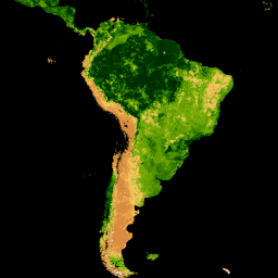
MOD15A2H V6.1 MODIS 結合葉面積指数(LAI)と光合成有効放射率(FPAR)プロダクトは、500 m の解像度の 8 日間複合データセットです。アルゴリズムは、8 日間の期間内の Terra センサーのすべての取得から利用可能な「最適な」ピクセルを選択します。
ドキュメント:
バンド
ピクセルサイズ
500 メートル
バンド
| 名前 | 単位 | 最小 | 最大 | スケール | ピクセルサイズ | 説明 |
|---|---|---|---|---|---|---|
Fpar_500m |
% | 0 | 100 | 0.01 | メートル | 光合成有効放射の割合 |
Lai_500m |
面積比率 | 0 | 100 | 0.1 | メートル | 葉面積指数 |
FparLai_QC |
0 | 254 | メートル | LAI と FPAR の品質 |
||
FparExtra_QC |
0 | 254 | メートル | LAI と FPAR の詳細品質 |
||
FparStdDev_500m |
% | 0 | 100 | 0.01 | メートル | FPAR の標準偏差 |
LaiStdDev_500m |
面積比率 | 0 | 100 | 0.1 | メートル | LAI の標準偏差 |
利用規約
利用規約
LP DAAC を通じて取得した MODIS データとプロダクトには、その後の使用、販売、再配布に関する制限はありません。
引用
引用:
LP DAAC データセットの引用については、LP DAAC の「Citing Our Data」ページを参照してください。
DOI
Earth Engine で探索する
コードエディタ(JavaScript)
var collection = ee.ImageCollection('MODIS/061/MOD15A2H')
                  .filterDate('2019-01-01', '2019-10-01');

var colorizedVis = {
  min: 0,
  max: 100,
  palette: [
    'ffffff', 'ce7e45', 'df923d', 'f1b555', 'fcd163', '99b718', '74a901',
    '66a000', '529400', '3e8601', '207401', '056201', '004c00', '023b01',
    '012e01', '011d01', '011301'
  ],
};

Map.setCenter(-10.88, 40.94, 2);
Map.addLayer(collection.select('Lai_500m'), colorizedVis, 'Lai');
Map.addLayer(collection.select('Fpar_500m'), colorizedVis, 'Fpar');