- データセットの利用可能な期間
- 2000-02-01T00:00:00Z–2026-01-01T00:00:00Z
- データセット プロデューサー
- USGS EROS センターの NASA LP DAAC
- ケイデンス
- 1 か月
- タグ
説明
MOD13A3 V6.1 プロダクト データは、空間解像度 1 km で毎月提供されます。この月次プロダクトを生成する際、アルゴリズムは、その月と重複するすべての MOD13A2 プロダクトを取り込み、時間加重平均を使用します。
植生指数は、植生状態のグローバル モニタリングに使用され、土地被覆と土地被覆の変化を表示するプロダクトで使用されます。これらのデータは、地球規模の生物地球化学的プロセスと水文プロセス、地球規模と地域規模の気候をモデル化するための入力として使用できます。その他の用途としては、一次生産や土地被覆の転換など、地表の生物物理学的特性とプロセスを特徴付けることが挙げられます。
ドキュメント:
バンド
ピクセルサイズ
1,000 メートル
バンド
| 名前 | 単位 | 最小 | 最大 | スケール | ピクセルサイズ | 波長 | 説明 | ||||||||||||||||||||||||||||||||||||||||||||||||||||||||||||||||||||||||||||||||||||||||||||
|---|---|---|---|---|---|---|---|---|---|---|---|---|---|---|---|---|---|---|---|---|---|---|---|---|---|---|---|---|---|---|---|---|---|---|---|---|---|---|---|---|---|---|---|---|---|---|---|---|---|---|---|---|---|---|---|---|---|---|---|---|---|---|---|---|---|---|---|---|---|---|---|---|---|---|---|---|---|---|---|---|---|---|---|---|---|---|---|---|---|---|---|---|---|---|---|---|---|---|---|
NDVI |
-2000 | 10,000 | 0.0001 | メートル | なし | 月間 NDVI 平均値 |
|||||||||||||||||||||||||||||||||||||||||||||||||||||||||||||||||||||||||||||||||||||||||||||
EVI |
-2000 | 10,000 | 0.0001 | メートル | なし | 月間 EVI 平均 |
|||||||||||||||||||||||||||||||||||||||||||||||||||||||||||||||||||||||||||||||||||||||||||||
DetailedQA |
メートル | なし | VI 品質指標 |
||||||||||||||||||||||||||||||||||||||||||||||||||||||||||||||||||||||||||||||||||||||||||||||||
sur_refl_b01 |
0 | 10,000 | 0.0001 | メートル | 620 ~ 670 nm | バンド 1(赤)の地表反射率 |
|||||||||||||||||||||||||||||||||||||||||||||||||||||||||||||||||||||||||||||||||||||||||||||
sur_refl_b02 |
0 | 10,000 | 0.0001 | メートル | 841 ~ 876 nm | バンド 2(近赤外線)の地表反射率 |
|||||||||||||||||||||||||||||||||||||||||||||||||||||||||||||||||||||||||||||||||||||||||||||
sur_refl_b03 |
0 | 10,000 | 0.0001 | メートル | 459 ~ 479 nm | バンド 3(青)の地表反射率 |
|||||||||||||||||||||||||||||||||||||||||||||||||||||||||||||||||||||||||||||||||||||||||||||
sur_refl_b07 |
0 | 10,000 | 0.0001 | メートル | 2,105 ~ 2,155 nm | バンド 7 の地表反射率(中赤外) |
|||||||||||||||||||||||||||||||||||||||||||||||||||||||||||||||||||||||||||||||||||||||||||||
ViewZenith |
度 | 0 | 18000 | 0.01 | メートル | なし | VI ピクセルの天頂角を表示する |
||||||||||||||||||||||||||||||||||||||||||||||||||||||||||||||||||||||||||||||||||||||||||||
SolarZenith |
度 | 0 | 18000 | 0.01 | メートル | なし | VI ピクセルの太陽天頂角 |
||||||||||||||||||||||||||||||||||||||||||||||||||||||||||||||||||||||||||||||||||||||||||||
RelativeAzimuth |
度 | -18000 | 18000 | 0.01 | メートル | なし | VI ピクセルの相対方位角 |
||||||||||||||||||||||||||||||||||||||||||||||||||||||||||||||||||||||||||||||||||||||||||||
SummaryQA |
メートル | なし | VI ピクセルの品質の信頼性 |
||||||||||||||||||||||||||||||||||||||||||||||||||||||||||||||||||||||||||||||||||||||||||||||||
SummaryQA クラステーブル
| 値 | 色 | 説明 |
|---|---|---|
| 0 | なし | Good Data: 安心して使用できる |
| 1 | なし | 限界データ: 役立つが、他の QA 情報も確認する |
| 2 | なし | 雪氷: ターゲットが雪氷で覆われている |
| 3 | なし | 曇り: ターゲットが見えない、雲で覆われている |
利用規約
利用規約
LP DAAC を通じて取得した MODIS データとプロダクトには、その後の使用、販売、再配布に関する制限はありません。
引用
引用:
LP DAAC データセットの引用については、LP DAAC の「Citing Our Data」ページを参照してください。
DOI
Earth Engine で探索する
コードエディタ(JavaScript)
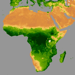
var dataset = ee.ImageCollection('MODIS/061/MOD13A3')
                  .filter(ee.Filter.date('2020-01-01', '2023-05-01'));
var ndvi = dataset.select('NDVI');
var ndviVis = {
  min: 0,
  max: 9000,
  palette: [
    'ffffff', 'ce7e45', 'df923d', 'f1b555', 'fcd163', '99b718', '74a901',
    '66a000', '529400', '3e8601', '207401', '056201', '004c00', '023b01',
    '012e01', '011d01', '011301'
  ],
};
Map.setCenter(6.746, 46.529, 2);
Map.addLayer(ndvi, ndviVis, 'NDVI');