- データセットの利用可能な期間
- 2000-02-24T00:00:00Z–2026-02-13T00:00:00Z
- データセット プロデューサー
- USGS EROS センターの NASA LP DAAC
- ケイデンス
- 1 日
- タグ
説明
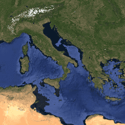
MCD43A4 V6.1 Nadir Bidirectional Reflectance Distribution Function Adjusted Reflectance(NBAR)プロダクトは、MODIS の「陸地」バンド 1 ~ 7 の 500 メートルの反射率データを提供します。これらは、天底ビューから収集されたかのように値をモデル化するために、双方向反射率分布関数を使用して調整されます。データは 16 日間の取得期間に基づいて毎日生成され、画像の日付は 9 日目になります。このプロダクトは、Terra と Aqua の両方の宇宙船からのデータを組み合わせ、16 日間の期間から最適な代表ピクセルを選択します。
ドキュメント:
バンド
ピクセルサイズ
500 メートル
バンド
| 名前 | 最小 | 最大 | スケール | ピクセルサイズ | 波長 | 説明 | |||||||||||||||||||||||||||||||||||||||||||||||||||||||||||||||||||||||||||||||||||||||||||||
|---|---|---|---|---|---|---|---|---|---|---|---|---|---|---|---|---|---|---|---|---|---|---|---|---|---|---|---|---|---|---|---|---|---|---|---|---|---|---|---|---|---|---|---|---|---|---|---|---|---|---|---|---|---|---|---|---|---|---|---|---|---|---|---|---|---|---|---|---|---|---|---|---|---|---|---|---|---|---|---|---|---|---|---|---|---|---|---|---|---|---|---|---|---|---|---|---|---|---|---|
Nadir_Reflectance_Band1 |
0 | 32766 | 0.0001 | メートル | 620 ~ 670 nm | バンド 1 のローカル太陽正午の NBAR |
|||||||||||||||||||||||||||||||||||||||||||||||||||||||||||||||||||||||||||||||||||||||||||||
Nadir_Reflectance_Band2 |
0 | 32766 | 0.0001 | メートル | 841 ~ 876 nm | バンド 2 の正午の NBAR |
|||||||||||||||||||||||||||||||||||||||||||||||||||||||||||||||||||||||||||||||||||||||||||||
Nadir_Reflectance_Band3 |
0 | 32766 | 0.0001 | メートル | 459 ~ 479 nm | バンド 3 のローカル太陽正午の NBAR |
|||||||||||||||||||||||||||||||||||||||||||||||||||||||||||||||||||||||||||||||||||||||||||||
Nadir_Reflectance_Band4 |
0 | 32766 | 0.0001 | メートル | 545 ~ 565 nm | バンド 4 のローカル太陽正午の NBAR |
|||||||||||||||||||||||||||||||||||||||||||||||||||||||||||||||||||||||||||||||||||||||||||||
Nadir_Reflectance_Band5 |
0 | 32766 | 0.0001 | メートル | 1230 ~ 1250 nm | バンド 5 のローカル太陽正午の NBAR |
|||||||||||||||||||||||||||||||||||||||||||||||||||||||||||||||||||||||||||||||||||||||||||||
Nadir_Reflectance_Band6 |
0 | 32766 | 0.0001 | メートル | 1628 ~ 1652 nm | バンド 6 の地方太陽正午における NBAR |
|||||||||||||||||||||||||||||||||||||||||||||||||||||||||||||||||||||||||||||||||||||||||||||
Nadir_Reflectance_Band7 |
0 | 32766 | 0.0001 | メートル | 2105 ~ 2155 nm | バンド 7 の地方太陽正午における NBAR |
|||||||||||||||||||||||||||||||||||||||||||||||||||||||||||||||||||||||||||||||||||||||||||||
BRDF_Albedo_Band_Mandatory_Quality_Band1 |
メートル | なし | バンド 1 の BRDF アルベドの必須品質 |
||||||||||||||||||||||||||||||||||||||||||||||||||||||||||||||||||||||||||||||||||||||||||||||||
BRDF_Albedo_Band_Mandatory_Quality_Band2 |
メートル | なし | バンド 2 の BRDF アルベドの必須品質 |
||||||||||||||||||||||||||||||||||||||||||||||||||||||||||||||||||||||||||||||||||||||||||||||||
BRDF_Albedo_Band_Mandatory_Quality_Band3 |
メートル | なし | バンド 3 の BRDF アルベドの必須品質 |
||||||||||||||||||||||||||||||||||||||||||||||||||||||||||||||||||||||||||||||||||||||||||||||||
BRDF_Albedo_Band_Mandatory_Quality_Band4 |
メートル | なし | バンド 4 の BRDF アルベドの必須品質 |
||||||||||||||||||||||||||||||||||||||||||||||||||||||||||||||||||||||||||||||||||||||||||||||||
BRDF_Albedo_Band_Mandatory_Quality_Band5 |
メートル | なし | バンド 5 の BRDF アルベドの必須品質 |
||||||||||||||||||||||||||||||||||||||||||||||||||||||||||||||||||||||||||||||||||||||||||||||||
BRDF_Albedo_Band_Mandatory_Quality_Band6 |
メートル | なし | バンド 6 の BRDF アルベドの必須品質 |
||||||||||||||||||||||||||||||||||||||||||||||||||||||||||||||||||||||||||||||||||||||||||||||||
BRDF_Albedo_Band_Mandatory_Quality_Band7 |
メートル | なし | バンド 7 の BRDF アルベドの必須品質 |
||||||||||||||||||||||||||||||||||||||||||||||||||||||||||||||||||||||||||||||||||||||||||||||||
利用規約
利用規約
LP DAAC を通じて取得した MODIS データとプロダクトには、その後の使用、販売、再配布に関する制限はありません。
引用
LP DAAC データセットの引用については、LP DAAC の「Citing Our Data」ページを参照してください。
DOI
Earth Engine で探索する
コードエディタ(JavaScript)
var dataset = ee.ImageCollection('MODIS/061/MCD43A4')
                  .filter(ee.Filter.date('2018-04-01', '2018-06-01'));
var trueColor = dataset.select([
  'Nadir_Reflectance_Band1', 'Nadir_Reflectance_Band4',
  'Nadir_Reflectance_Band3'
]);
var trueColorVis = {
  min: 0.0,
  max: 4000.0,
  gamma: 1.4,
};
Map.setCenter(-7.03125, 31.0529339857, 2);
Map.addLayer(trueColor, trueColorVis, 'True Color');