- データセットの利用可能な期間
- 2000-02-24T00:00:00Z–2026-02-20T23:40:00Z
- データセット プロデューサー
- USGS EROS センターの NASA LP DAAC
- ケイデンス
- 1 日
- タグ
説明
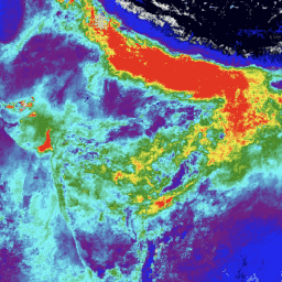
MCD19A2 V6.1 データ プロダクトは、MODIS Terra と Aqua を組み合わせた Multi-angle Implementation of Atmospheric Correction(MAIAC)Land Aerosol Optical Depth(AOD)グリッド化レベル 2 プロダクトで、1 km の解像度で毎日生成されます。詳細については、MAIAC ユーザーガイドをご覧ください。
注: このプロダクトは、ミッション全体の再処理が 2023 年の夏まで継続される予定であるという注意書きとともにリリースされています。
バンド
ピクセルサイズ
1,000 メートル
バンド
| 名前 | 単位 | 最小 | 最大 | スケール | ピクセルサイズ | 説明 | |||||||||||||||||||||||||||||||||||||||||||||||||||||||||||||||||||||||||||||||||||||||||||||
|---|---|---|---|---|---|---|---|---|---|---|---|---|---|---|---|---|---|---|---|---|---|---|---|---|---|---|---|---|---|---|---|---|---|---|---|---|---|---|---|---|---|---|---|---|---|---|---|---|---|---|---|---|---|---|---|---|---|---|---|---|---|---|---|---|---|---|---|---|---|---|---|---|---|---|---|---|---|---|---|---|---|---|---|---|---|---|---|---|---|---|---|---|---|---|---|---|---|---|---|
Optical_Depth_047 |
-100 | 8000 | 0.001 | メートル | MODIS ブルーバンド(0.47 μm)で取得された陸上のエアロゾル光学的厚さ。煙や塵が検出された場合を除き、高度が高い場合(4.2 km を超える場合)は AOD を取得しません。代わりに、大気補正に使用される静的な値 0.02 を報告します。 |
||||||||||||||||||||||||||||||||||||||||||||||||||||||||||||||||||||||||||||||||||||||||||||||
Optical_Depth_055 |
-100 | 8000 | 0.001 | メートル | MODIS グリーンバンド(0.55 μm)で取得された陸上のエアロゾル光学的厚さ。 |
||||||||||||||||||||||||||||||||||||||||||||||||||||||||||||||||||||||||||||||||||||||||||||||
AOD_Uncertainty |
0 | 30000 | 0.0001 | メートル | 青色バンドの地表の明るさ(反射率)に基づく AOD の不確実性 |
||||||||||||||||||||||||||||||||||||||||||||||||||||||||||||||||||||||||||||||||||||||||||||||
FineModeFraction |
0 | 1,000 | メートル | 海洋と内陸の大きな湖の微細モードの割合 |
|||||||||||||||||||||||||||||||||||||||||||||||||||||||||||||||||||||||||||||||||||||||||||||||
Column_WV |
cm | 0 | 30000 | 0.001 | メートル | 陸上の水蒸気カラム。MODIS の近赤外バンド(0.94 μm)から取得。曇ったピクセルについて報告された場合、雲の上の水蒸気を表します。 |
|||||||||||||||||||||||||||||||||||||||||||||||||||||||||||||||||||||||||||||||||||||||||||||
AOD_QA |
メートル | AOD QA |
|||||||||||||||||||||||||||||||||||||||||||||||||||||||||||||||||||||||||||||||||||||||||||||||||
Injection_Height |
m | 0 | 10,000 | メートル | 煙の注入高さ |
||||||||||||||||||||||||||||||||||||||||||||||||||||||||||||||||||||||||||||||||||||||||||||||
AngstromExp_470-780 |
0.0001 | メートル | 海洋上のオングストローム指数 470 ~ 780 nm |
||||||||||||||||||||||||||||||||||||||||||||||||||||||||||||||||||||||||||||||||||||||||||||||||
cosSZA |
0 | 10,000 | 0.0001 | メートル | 太陽天頂角の余弦(5 km 解像度) |
||||||||||||||||||||||||||||||||||||||||||||||||||||||||||||||||||||||||||||||||||||||||||||||
cosVZA |
0 | 10,000 | 0.0001 | メートル | 視線天頂角のコサイン(5 km 解像度) |
||||||||||||||||||||||||||||||||||||||||||||||||||||||||||||||||||||||||||||||||||||||||||||||
RelAZ |
-18000 | 18000 | 0.01 | メートル | 相対方位角(5 km 解像度) |
||||||||||||||||||||||||||||||||||||||||||||||||||||||||||||||||||||||||||||||||||||||||||||||
Scattering_Angle |
-18000 | 18000 | 0.01 | メートル | 散乱角(5 km 解像度) |
||||||||||||||||||||||||||||||||||||||||||||||||||||||||||||||||||||||||||||||||||||||||||||||
Glint_Angle |
-18000 | 18000 | 0.01 | メートル | グレア角(5 km 解像度) |
||||||||||||||||||||||||||||||||||||||||||||||||||||||||||||||||||||||||||||||||||||||||||||||
利用規約
利用規約
LP DAAC を通じて取得した MODIS データとプロダクトには、その後の使用、販売、再配布に関する制限はありません。
引用
LP DAAC データセットの引用については、LP DAAC の「Citing Our Data」ページを参照してください。
DOI
Earth Engine で探索する
コードエディタ(JavaScript)
var collection = ee.ImageCollection('MODIS/061/MCD19A2_GRANULES')
                     .select('Optical_Depth_047')
                     .filterDate('2023-01-01', '2023-01-15');

var band_viz = {
  min: 0,
  max: 1100,
  palette: ['black', 'blue', 'purple', 'cyan', 'green', 'yellow', 'red']
};

Map.addLayer(collection.mean(), band_viz, 'Optical Depth 047');
Map.setCenter(76, 13, 6);