- データセットの利用可能な期間
- 2000-02-24T00:00:00Z–2024-06-01T00:00:00Z
- データセット プロデューサー
- USGS EROS センターの NASA LP DAAC
- ケイデンス
- 1 日
- タグ
説明
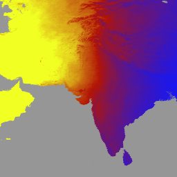
MCD18A1 バージョン 6.1 は、中解像度画像分光放射計(MODIS)Terra と Aqua を組み合わせた下向き短波放射(DSR)グリッド化レベル 3 プロダクトです。毎日 1 キロメートルのピクセル解像度で生成され、3 時間ごとに DSR の推定値が提供されます。DSR は、短波スペクトル(300 ~ 4,000 ナノメートル)の陸地表面に降り注ぐ太陽放射であり、さまざまな科学的およびアプリケーションの問題に対処する陸地表面モデルの重要な変数です。MCD18 プロダクトは、MODIS データの多時相シグネチャを使用して地表反射率を導出し、ルックアップ テーブル(LUT)アプローチを使用して入射 DSR を計算するプロトタイピング アルゴリズムに基づいています。LUT は、さまざまな照明/視点のジオメトリで、エアロゾルと雲のさまざまな種類の負荷を考慮します。グローバル DSR プロダクトは、MODIS と静止衛星データから生成されます。データの作成に使用された方法論に関する詳細については、アルゴリズムの理論的根拠に関するドキュメントをご覧ください。
バンド
ピクセルサイズ
500 メートル
バンド
| 名前 | 単位 | 最小 | 最大 | ピクセルサイズ | 説明 | ||||||||||||||||||||||||||||||||||||||||||||||||||||||||||||||||||||||||||||||||||||||||||||||
|---|---|---|---|---|---|---|---|---|---|---|---|---|---|---|---|---|---|---|---|---|---|---|---|---|---|---|---|---|---|---|---|---|---|---|---|---|---|---|---|---|---|---|---|---|---|---|---|---|---|---|---|---|---|---|---|---|---|---|---|---|---|---|---|---|---|---|---|---|---|---|---|---|---|---|---|---|---|---|---|---|---|---|---|---|---|---|---|---|---|---|---|---|---|---|---|---|---|---|---|
DSR |
W/m^2 | 0 | 1400 | メートル | MODIS 通過時の瞬間の合計 DSR |
||||||||||||||||||||||||||||||||||||||||||||||||||||||||||||||||||||||||||||||||||||||||||||||
Direct |
W/m^2 | 0 | 1400 | メートル | MODIS 通過時の瞬時直接 DSR |
||||||||||||||||||||||||||||||||||||||||||||||||||||||||||||||||||||||||||||||||||||||||||||||
Diffuse |
W/m^2 | 0 | 1400 | メートル | MODIS 通過時の瞬時拡散 DSR |
||||||||||||||||||||||||||||||||||||||||||||||||||||||||||||||||||||||||||||||||||||||||||||||
GMT_0000_DSR |
W/m^2 | 0 | 1400 | メートル | GMT 00:00 の合計 DSR |
||||||||||||||||||||||||||||||||||||||||||||||||||||||||||||||||||||||||||||||||||||||||||||||
GMT_0300_DSR |
W/m^2 | 0 | 1400 | メートル | GMT 03:00 の合計 DSR |
||||||||||||||||||||||||||||||||||||||||||||||||||||||||||||||||||||||||||||||||||||||||||||||
GMT_0600_DSR |
W/m^2 | 0 | 1400 | メートル | GMT 06:00 の合計 DSR |
||||||||||||||||||||||||||||||||||||||||||||||||||||||||||||||||||||||||||||||||||||||||||||||
GMT_0900_DSR |
W/m^2 | 0 | 1400 | メートル | GMT 09:00 の合計 DSR |
||||||||||||||||||||||||||||||||||||||||||||||||||||||||||||||||||||||||||||||||||||||||||||||
GMT_1200_DSR |
W/m^2 | 0 | 1400 | メートル | GMT 12:00 の合計 DSR |
||||||||||||||||||||||||||||||||||||||||||||||||||||||||||||||||||||||||||||||||||||||||||||||
GMT_1500_DSR |
W/m^2 | 0 | 1400 | メートル | GMT 15:00 の合計 DSR |
||||||||||||||||||||||||||||||||||||||||||||||||||||||||||||||||||||||||||||||||||||||||||||||
GMT_1800_DSR |
W/m^2 | 0 | 1400 | メートル | GMT 18:00 の合計 DSR |
||||||||||||||||||||||||||||||||||||||||||||||||||||||||||||||||||||||||||||||||||||||||||||||
GMT_2100_DSR |
W/m^2 | 0 | 1400 | メートル | GMT 21:00 の合計 DSR |
||||||||||||||||||||||||||||||||||||||||||||||||||||||||||||||||||||||||||||||||||||||||||||||
DSR_Quality |
メートル | 品質フラグ |
|||||||||||||||||||||||||||||||||||||||||||||||||||||||||||||||||||||||||||||||||||||||||||||||||
利用規約
利用規約
LP DAAC を通じて取得した MODIS データとプロダクトには、その後の使用、販売、再配布に関する制限はありません。
引用
LP DAAC データセットの引用については、LP DAAC の「Citing Our Data」ページを参照してください。
DOI
Earth Engine で探索する
コードエディタ(JavaScript)
var dataset = ee.ImageCollection('MODIS/061/MCD18A1')
                  .filter(ee.Filter.date('2000-01-01', '2001-01-01'));
var gmt_1200_dsr = dataset.select('GMT_1200_DSR');
var gmt_1200_dsr_vis = {
  min: 0,
  max: 350,
  palette: ['0f17ff', 'b11406', 'f1ff23'],
};
Map.setCenter(6.746, 46.529, 2);
Map.addLayer(
    gmt_1200_dsr, gmt_1200_dsr_vis,
    'Total dsr at GMT 12:00');