- データセットの利用可能な期間
- 2014-09-01T00:00:00Z–2014-09-01T00:00:00Z
- データセット プロデューサー
- 米国農務省(USDA)、米国森林局(USFS)、米国内務省地質調査所(USGS)、The Nature Conservancy。
- タグ
説明
LANDFIRE(LF)、Landscape Fire and Resource Management Planning Tools は、米国農務省林野部、米国内務省地質調査所、ザ ネイチャー コンサーバンシーの山火事管理プログラム間の共有プログラムです。
LANDFIRE(LF)レイヤは、分類木と回帰木を使用して、広範なフィールド参照データ、衛星画像、生物物理学的グラデーション レイヤに基づく予測ランドスケープ モデルを使用して作成されます。
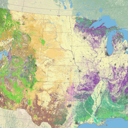
既存の植生高(EVH)は、30 m セルの優占植生の平均高を表します。樹冠の高さは、トレーニング データやその他の地理空間レイヤを使用して、樹木、低木、草本植物ごとに個別に生成されます。EVH は、種被覆率で重み付けされた平均樹高と、既存の植生タイプ(EVT)のライフフォームに基づいて決定されます。
フィールド参照データ、ライダー、Landsat、補助データを使用する決定木モデルは、各生物ごとに個別に開発されます。決定木の関係を使用して、生物固有の高さクラスレイヤを生成し、単一の複合 EVH レイヤに統合します。
擾乱データは、LFRDB プロット フィルタリング用の LF Remap プロダクトの開発に使用され、ソース画像に表示されない 2015 年と 2016 年の擾乱が含まれるようにしました。
その後、EVC プロダクトは QA/QC 対策を通じて調整され、生物が既存の植生被覆と EVT プロダクトの両方と同期されるようになります。
LF は、燃料製品の開発など、後続の複数のレイヤで EVH を使用しています。
LANDIFRE Vegetation データセットには、次のものが含まれます。
- 生体物理学的設定(BPS)
- 環境サイトの可能性(ESP)
- 既存の植生被覆率(EVC)
- 既存の植生高(EVH)。
- 既存の植生タイプ(EVT) これらのレイヤは、分類木と回帰木を使用して、広範なフィールド参照データ、衛星画像、生物物理学的グラデーション レイヤに基づいて予測ランドスケープ モデルを使用して作成されます。
バンド
ピクセルサイズ
30 メートル
バンド
| 名前 | ピクセルサイズ | 説明 |
|---|---|---|
EVH |
メートル | 既存の植生の高さ |
画像プロパティ検出
画像プロパティ
| 名前 | 型 | 説明 |
|---|---|---|
| EVH_classes | DOUBLE | 既存の植生の高さのクラス値。 |
| EVH_names | STRING | 既存の植生の高さのわかりやすい名前。 |
利用規約
利用規約
LANDFIRE データは使用制限のないパブリック ドメイン データですが、プロダクトの変更や派生物を作成する場合は、混乱を避けるために、データセットに説明的な修飾子を追加してください。
引用
LANDFIRE プロダクトの引用方法の推奨事項はプロダクトごとに異なるため、引用のモデルが提供され、特定のプロダクトの例が示されています。プロデューサー。リリース年。プロダクト xxxxx:
- 個々のモデル名。
- BpS モデルと説明(オンライン)。LANDFIRE。ワシントン DC。米国農務省森林局
- 米国内務省、米国地質調査所、バージニア州アーリントン
- The Nature Conservancy(プロデューサー)。利用可能な URL。アクセス日。
引用例: LANDFIRE Biophysical Settings. 2018 年。生物物理学的設定 14420: 南テキサス州の砂丘草原。LANDFIRE Biophysical Setting Model: Map zone 36, [Online]. In: BpS Models and Descriptions. In: LANDFIRE. ワシントン DC: 米国農務省森林局、米国内務省、米国地質調査所。アーリントン(バージニア州): ザ ネイチャー コンサーバンシー(制作)。参照先: https://www.landfire.gov/bps-models.php [2018 年 6 月 27 日]。LANDFIRE プロダクトの引用に関する追加のガイダンスについては、こちらをご覧ください。
Earth Engine で探索する
コードエディタ(JavaScript)
var dataset = ee.ImageCollection('LANDFIRE/Vegetation/EVH/v1_4_0');

var visualization = {
  bands: ['EVH'],
};

Map.setCenter(-121.671, 40.699, 5);

Map.addLayer(dataset, visualization, 'EVH');