- データセットの利用可能な期間
- 2017-01-01T00:00:00Z–2018-01-01T00:00:00Z
- データセット プロデューサー
- K. 北Toosi University of Technology LiDAR Lab
- タグ
説明
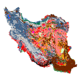
イラン全土の土地被覆地図は、Google Earth Engine Cloud プラットフォーム内で Sentinel 画像を処理して生成されました。この目的のために、2,500 枚を超える Sentinel-1 画像と 11,000 枚を超える Sentinel-2 画像が処理され、2017 年の単一のモザイク データセットが生成されました。次に、13 個のクラスの多数の参照サンプルでオブジェクトベースのランダム フォレスト分類法をトレーニングし、イラン全土の土地被覆マップを生成しました。
バンド
バンド
| 名前 | ピクセルサイズ | 説明 |
|---|---|---|
classification |
10 メートル | 分類 |
分類クラス テーブル
| 値 | 色 | 説明 |
|---|---|---|
| 1 | #000000 | 都市部 |
| 2 | #006eff | 水 |
| 3 | #41a661 | 湿地帯 |
| 4 | #ff7f7f | Kalut(ヤルダン) |
| 5 | #bee8ff | 湿地 |
| 6 | #ff00c5 | Salty Land |
| 7 | #ff0000 | Clay |
| 8 | #00734c | 森 |
| 9 | #732600 | 露頭 |
| 10 | #ffaa00 | Uncovered Plain |
| 11 | #d3ffbe | 砂 |
| 12 | #446589 | 農地 |
| 13 | #cccccc | Range Land |
利用規約
利用規約
Arsalan Ghorbanian、Mohammad Kakooei、Meisam Amani、Sahel Mahdavi、Ali Mohammadzadeh、Mahdi Hasanlou による「Iran Land Cover Map v1 13-class (2017)」は、クリエイティブ・コモンズの表示 4.0 国際ライセンス(CC BY 4.0)の下でライセンスされています。
引用
Ghorbanian, A.、Kakooei, M.、Amani, M.、Mahdavi, S.、Mohammadzadeh, A.、& Hasanlou, M. (2020 年)。Google Earth Engine 内の Sentinel 画像と、移行されたトレーニング サンプルを使用した土地被覆分類の新しい自動ワークフローを使用して、イランの土地被覆地図を改善しました。ISPRS Journal of Photogrammetry and Remote Sensing, 167, 276-288. doi:10.1016/j.isprsjprs.2020.07.013
Earth Engine で探索する
コードエディタ(JavaScript)
var dataset = ee.Image('KNTU/LiDARLab/IranLandCover/V1');

var visualization = {
  bands: ['classification']
};

Map.setCenter(54.0, 33.0, 5);

Map.addLayer(dataset, visualization, 'Classification');