- データセットの利用可能な期間
- 2001-01-01T00:00:00Z–2021-01-01T00:00:00Z
- データセット プロデューサー
- 欧州委員会、合同研究センター、Global Wildfire Information System
- タグ
説明
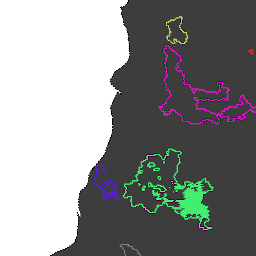
MODIS データセット MCD64A1 に基づく火災境界。このデータは、焼失地域のパッチ間の時空間関係をグラフ構造でエンコードするアルゴリズムに基づいて計算されました。
各火災には、イベントを識別する一意の番号が割り当てられています。
テーブル スキーマ
テーブル スキーマ
| 名前 | 型 | 説明 |
|---|---|---|
| 面積 | DOUBLE | 火災の範囲(平方メートル) |
| FinalDate | INT | 最終的なリリース日(1970 年 1 月 1 日からのミリ秒単位) |
| ID | INT | 火災の数値 ID |
| InitialDate | INT | 1970 年 1 月 1 日からのミリ秒単位の初回起動日 |
利用規約
利用規約
引用
引用:
Artés, T.、Oom, D.、De Rigo, D.、Durrant, T. H., Maianti, P.、Libertà, G.、& San-Miguel-Ayanz, J. (2019 年)火災発生パターンと火災の挙動の分析に使用する、世界規模の山火事データセット。Scientific data、6(1)、1 ~ 11。 doi:10.1038/s41597-019-0312-2
DOI
Earth Engine で探索する
コードエディタ(JavaScript)
var dataset = ee.FeatureCollection('JRC/GWIS/GlobFire/v2/FinalPerimeters');
var visParams = {
  palette: ['f5ff64', 'b5ffb4', 'beeaff', 'ffc0e8', '8e8dff', 'adadad'],
  min: 0,
  max: 600000000,
  opacity: 0.8,
};
var image = ee.Image().float().paint(dataset, 'area');
Map.addLayer(image, visParams, 'GlobFire Final');
Map.addLayer(dataset, null, 'for Inspector', false);
Map.setCenter(-122.121, 38.56, 12);