- データセットの利用可能な期間
- 2006-01-01T00:00:00Z–2015-06-10T00:00:00Z
- データセット プロデューサー
- Global Forest Watch、World Resources Institute
- タグ
説明
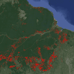
FORMA は、湿潤熱帯林を対象とした MODIS ベースの森林破壊アラート システムです。FORMA は、森林被覆の損失が新たに発生した地域を迅速に特定できるように設計されています。このシステムは、NASA の Terra 衛星と Aqua 衛星で動作する MODIS センサーによって毎日収集されたデータを分析します。FORMA アラート システムは、植生の緑度を測定する NDVI(正規化植生指数)で測定された植生被覆の顕著な変化を検出します。植生被覆の大きな変化は、森林の伐採、焼却、落葉を示している可能性があります。ピクセル値を変更が検出された日付に設定することで、アラートがデータセットに追加されます。FORMA アラートは、森林被覆の損失確率が 50% 以上の地域でのみ表示されます。FORMA データの空間分解能は 500 メートルで、更新間隔は月 2 回です。FORMA アラートは 2006 年 1 月に開始されました。
バンド
ピクセルサイズ
500 メートル
バンド
| 名前 | 単位 | 最小 | 最大 | ピクセルサイズ | 説明 |
|---|---|---|---|---|---|
constant |
秒 | 1.13498e+09* | 1.43392e+09* | メートル |
利用規約
利用規約
FORMA データセットは、使用または配布に制限なく利用できます。ただし、WRI は、ユーザーが適切な帰属表示を行い、該当する場合は WRI と GFW をデータのソースとして特定することを求めています。
引用
引用:
Hammer、Dan、Robin Kraft、David Wheeler。2013 年。FORMA アラート。World Resources Institute および Center for Global Development。 www.globalforestwatch.org。
Earth Engine で探索する
コードエディタ(JavaScript)
var dataset = ee.Image('FORMA/FORMA_500m');

var visualization = {
  bands: ['constant'],
  min: 1134979200.0,
  max: 1433919600.0,
  palette: ['ff0000']
};

Map.setCenter(-51.482, -0.835, 6);

Map.addLayer(dataset, visualization, 'Alert Areas');