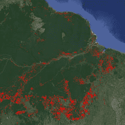
FORMA is a MODIS-based deforestation alerting system for the humid tropical
forests. FORMA is designed for quick identification of new areas of tree
cover loss. The system analyzes data gathered daily by the MODIS sensor,
which operates on NASA's Terra and Aqua satellites. The FORMA alerts system
then detects pronounced changes in vegetation cover over time, as measured
by the Normalized Difference Vegetation Index (NDVI), a measure of
vegetation greenness. These pronounced changes in vegetation cover are
likely to indicate forest being cleared, burned, or defoliated. An alert is
added to the dataset by setting the pixel value to the date at which a
change was detected. FORMA alerts only appear in areas where the probability
of tree cover loss is greater than or equal to 50%. FORMA data has 500-meter
spatial resolution and twice-monthly update interval. FORMA alerts start in
January 2006.
The FORMA datasets are available without restriction on use or distribution.
WRI does request that the user give proper attribution and identify WRI and
GFW, where applicable, as the source of the data.
Citations
Citations:
Hammer, Dan, Robin Kraft, and David Wheeler. 2013. FORMA Alerts. World
Resources Institute and Center for Global Development.
www.globalforestwatch.org.
FORMA is a MODIS-based deforestation alerting system for the humid tropical forests. FORMA is designed for quick identification of new areas of tree cover loss. The system analyzes data gathered daily by the MODIS sensor, which operates on NASA's Terra and Aqua satellites. The FORMA alerts system then detects pronounced …
[[["Easy to understand","easyToUnderstand","thumb-up"],["Solved my problem","solvedMyProblem","thumb-up"],["Other","otherUp","thumb-up"]],[["Missing the information I need","missingTheInformationINeed","thumb-down"],["Too complicated / too many steps","tooComplicatedTooManySteps","thumb-down"],["Out of date","outOfDate","thumb-down"],["Samples / code issue","samplesCodeIssue","thumb-down"],["Other","otherDown","thumb-down"]],[],[[["FORMA is a MODIS-based deforestation alerting system for the humid tropical forests designed for quick identification of new areas of tree cover loss."],["The system analyzes data from NASA's Terra and Aqua satellites to detect pronounced changes in vegetation cover, indicating potential forest clearing, burning, or defoliation."],["FORMA alerts are generated for areas with a probability of tree cover loss greater than or equal to 50% and are represented by pixel values corresponding to the date of change detection."],["This dataset has been superseded by WRI/GFW/FORMA/alerts and has a spatial resolution of 500 meters with a twice-monthly update interval, covering the period from January 2006 to June 2015."],["The FORMA datasets are available without restriction on use or distribution, with proper attribution requested to WRI and GFW as the data source."]]],["FORMA, a MODIS-based system, identifies new tree cover loss in humid tropical forests by analyzing daily data from NASA's Terra and Aqua satellites. It uses the Normalized Difference Vegetation Index (NDVI) to detect changes indicative of clearing, burning, or defoliation. Alerts, represented by pixel values set to the change detection date, appear where tree cover loss probability is ≥50%. The data, updated twice-monthly, has a 500-meter spatial resolution and covers January 2006 to June 2015. This data is now deprecated.\n"]]