- データセットの利用可能な期間
- 1993-01-01T00:00:00Z–2021-06-16T00:00:00Z
- データセット プロデューサー
- エストニアのオルソフォト
- タグ
説明
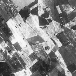
オルソ写真は、エストニアをカバーする航空写真データセットです。
オルソフォトとは、地形の起伏、撮影時のカメラの地面に対する傾き、カメラの中心投影によって生じた歪みが除去された、処理済みの航空写真です。デジタルオルソ画像には、特定のピクセル サイズまたは解像度があり、地上で分割できない最小の露出領域(地上サンプリング距離、GSD)を示します。
オルソ写真は全国を網羅しており、縮尺 1:5000 ~ 1:10000(ピクセル サイズ 20 ~ 40 cm)に対応しています。人口密集地のオルソ写真は、ピクセル サイズ 10 ~ 16 cm で作成されます。
モノクロ データセットには、全国をカバーする単一のグレースケール バンドが含まれています。
詳細については、エストニアのオルソフォトのドキュメントをご覧ください。
バンド
ピクセルサイズ
0.4 メートル
バンド
| 名前 | 最小 | 最大 | ピクセルサイズ | 説明 |
|---|---|---|---|---|
mono |
0 | 255 | メートル | グレースケール |
利用規約
利用規約
データは、ライセンサー(エストニア土地委員会など)にデータのタイトルと作成時期とともに適切な帰属表示を行うことを条件に、特定の期間を設けずに商用および非商用目的で自由に使用できます。
詳しくは、利用規約をご覧ください。
引用
引用:
地図データ: エストニア土地委員会
Earth Engine で探索する
コードエディタ(JavaScript)
var dataset = ee.ImageCollection('Estonia/Maamet/orthos/mono');
Map.setCenter(26.61312, 58.5879, 15);
Map.addLayer(dataset, null, 'Estonia Maamet mono');