- データセットの利用可能な期間
- 2000-01-01T00:00:00Z–2020-01-01T00:00:00Z
- データセット プロデューサー
- 国際地球科学情報ネットワークの NASA SEDAC
- タグ
説明
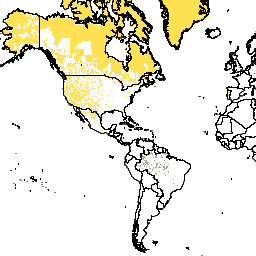
このデータセットは、GPW v4.11 の人口推定値の生成に使用された国勢調査のデータソースを表しています。同じ値を持つピクセルは、同じデータソース(通常は国または地域)を反映しています。
Gridded Population of World Version 4(GPWv4)、Revision 11 は、2000 年、2005 年、2010 年、2015 年、2020 年の世界の人口分布を 30 秒(約 1 km)のグリッド セルでモデル化しています。人口は、国勢調査と行政単位の人口の比例配分を使用してセルに分布されます。人口入力データは、2005 年から 2014 年の間に実施された 2010 年の国勢調査の結果から得られる最も詳細な空間解像度で収集されます。入力データが外挿され、モデル化された各年の人口推定値が生成されます。
バンド
ピクセルサイズ
927.67 メートル
バンド
| 名前 | 最小 | 最大 | ピクセルサイズ | 説明 |
|---|---|---|---|---|
national_identifier_grid |
4* | 999* | メートル | GPWv4.11 の人口推定値の生成に使用された国勢調査データソースを表す整数。同じ値を持つピクセル(グリッド セル)は、同じデータソース(多くの場合、国または地域)を反映しています。なお、これらのデータは、提供された統計データが対象とする地域を表すものであり、国や地域の境界を公式に表すものではありません。 |
利用規約
利用規約
引用
コロンビア大学国際地球科学情報ネットワーク センター(CIESIN)。2018 年。Gridded Population of the World, Version 4(GPWv4): National Identifier Grid, Revision 11。Palisades, NY: NASA Socioeconomic Data and Applications Center(SEDAC)。https://doi.org/10.7927/H4F47M2C。Accessed DAY MONTH YEAR.
DOI
Earth Engine で探索する
コードエディタ(JavaScript)
var dataset = ee.ImageCollection('CIESIN/GPWv411/GPW_National_Identifier_Grid');
var raster = dataset.select('national_identifier_grid');
var raster_vis = {
  'min': 4.0,
  'palette': [
    '000000',
    'ffffff'
  ],
  'max': 999.0
};
Map.setCenter(-88.6, 26.4, 1);
Map.addLayer(raster, raster_vis, 'national_identifier_grid');