- データセットの利用可能な期間
- 2015-12-01T00:00:00Z–2015-12-01T00:00:00Z
- データセット プロデューサー
- Geoscience Australia
- タグ
説明
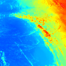
LiDAR モデルから導出されたオーストラリアの 5 メートル グリッドの数値標高モデル(DEM)は、2001 年から 2015 年の間に実施された約 236 件の個々の LiDAR 調査から導出された、245,000 平方キロメートルを超える地域をカバーする全国 5 メートル(裸地)DEM を表しています。これらの調査は、オーストラリアの人口密集地帯である沿岸部、マレーダーリング盆地内の氾濫原、主要な人口集中地と小規模な人口集中地の個別の調査を対象としています。利用可能な 1 メートルの解像度の LiDAR 由来の DEM はすべて、近傍平均法を使用して各調査地域の 5 メートルの解像度のデータセットにコンパイルおよびリサンプリングされ、その後、各州の単一のデータセットに統合されました。各状態のデータセットは、画像コレクション内の個別の画像として提供されます。
個々の LiDAR 調査の取得と 5 m プロダクトの導出は、National Elevation Data Framework と Coastal and Urban DEM Program の下で、Geoscience Australia、Cooperative Research Centre for Spatial Information(CRCSI)、Climate Change and Environment 省、州と準州の管轄区域、地方自治体、Murray Darling Basin Authority の間で長期にわたって行われてきた共同作業の一環です。ソース データセットは、オーストラリアの ICSM LiDAR 取得仕様とほぼ一致する基準で取得されています。この基準では、少なくとも 0.30 m(95% の信頼度)の基本的な垂直精度と、少なくとも 0.80 m(95% の信頼度)の水平精度が求められています。
パースの近くには、(115.85, -31.99)、(115.72, -33.75)、(115.10, -33.43) の周辺に null(NaN)値があるエリアがいくつかあります。
バンド
ピクセルサイズ
5 メートル
バンド
| 名前 | 単位 | ピクセルサイズ | 説明 |
|---|---|---|---|
elevation |
m | メートル | 高度 |
利用規約
利用規約
このデータセットは、クリエイティブ・コモンズの表示 4.0 国際ライセンスに基づいて Geoscience Australia が提供しています。データは、提供された引用と DOI で参照する必要があります。
引用
Geoscience Australia, 2015. LiDAR 5 メートル グリッドから導出されたオーストラリアの数値標高モデル(DEM)。Geoscience Australia、キャンベラ。
DOI
Earth Engine で探索する
コードエディタ(JavaScript)
var dataset = ee.ImageCollection('AU/GA/AUSTRALIA_5M_DEM');
var elevation = dataset.select('elevation');
var elevationVis = {
  min: 0.0,
  max: 150.0,
  palette: ['0000ff', '00ffff', 'ffff00', 'ff0000', 'ffffff'],
};
Map.setCenter(140.1883, -35.9113, 8);
Map.addLayer(elevation, elevationVis, 'Elevation');