您現在可以建立 KML 檔案來顯示天空中的物體,例如星星、星座、行星、月球和星系。本頁面說明如何建立 KML 檔案,以在「Google 星空」中顯示尖峰資料。具體而言,您必須完成下列事項:
- 在 KML 檔案開頭加上 hint 屬性,表示檔案包含天空資料,而非地球資料
- 將天體座標轉換為地球上的 KML 座標
天空模式
「Google 地球」使用者可透過使用者介面中的 [檢視] > [切換到天空功能表] 選項或 [天空] 按鈕,控制何時可切換到「星空」模式。當使用者切換至「天空」模式時,「Google 地球」會轉換以顯示從全球望遠鏡拍攝的天空圖像,以及外太空的空間。天空的景色就像是站在地球中心,向外看向外。這個模型可讓使用者探索頭部上方的天空,以及大部分只能從地球另一側看到的天體球體。
座標
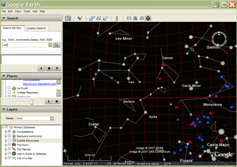
海拔高度座標會以右上升 (RA) 和衰減的方式描述。右上升點 (對應經度):代表太陽與天空中交界的赤道之間的距離。右側測量是從 0 到 24 小時進行測量,一個小時的 RA 等於一小時小時內,在地球表面的指定點上旋轉的量。新招攬 RA 的時數為 1 分,也就是即日起往來點,而 RA 從 Y 開始往東方增加。
下傾與緯度相似,0 度下震在赤道赤道上。衰減值範圍為直接為南波上方 -90° 至北北正上方的 +90°。
下圖顯示「Google 星空圖」的格線已啟用,用於顯示右方上升和衰減功能:
支援的元素
Google 地球 4.2 版天空模式支援下列元素:
- 地標
- 區域疊加層
- LineString
- Polygon
- 多重幾何圖形
- 線性環
- 點
- 樣式元素
- 容器元素
不過請注意,這些元素目前會忽略 <tilt> 和 <roll>。
hint 屬性
如果您的 KML 檔案包含 Sky 資料,請務必在檔案開頭的 <KML> 元素中加入提示屬性:
<kml xmlns="http://www.opengis.net/kml/2.2" hint="target=sky">
有 "target=sky" 提示的檔案載入時,如果 Google 地球已進入這個模式,系統會提示使用者切換至「天空檢視」。
轉換 Google 地球針對螢幕顯示座標
您必須執行一些簡單的計算,將右方上升座標 (小時/分鐘/秒) 轉換成經度,以便在 Google 地球 (天空模式) 正確顯示資料。
轉換右方座標
如要將從 0 到 24 之間的值,從 0 到 24 的範圍,將右方座標轉換為 -180° 到 +180° 之間的值,請使用以下公式,其中 hour、minute 和 second 是資料的原始右側切割值:
(hour + minute/60 + second/3600)*15 − 180
轉換衰減座標
十進位座標直接對應於緯度值,範圍從赤道南側的 -90° 到經度赤道以北 +90°。
LookAt 元素的計算範圍
搭配天空資料使用 <LookAt> 元素時,您必須執行下列計算來判斷範圍。基本公式如下:
r = R*(k*sin(β/2) - cos(β/2) + 1)
其中
- r
- 是在 <LookAt> 元素中指定的範圍
- R
- 是天空的半徑(在本範例中,因為地球是我們實際上在天空中),等於等於 6.378 x 10⁶
- k 鍵
- 等於 1/tan(alpha/2) 或 1.1917536
- 無
- 是將相機拉回天體中心 (地球) 中心時,Google 地球的視角範圍
- β
- 是天空圖片的弧形秒數。
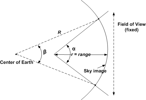
注意:Google 計算工具十分適合用來計算這類計算結果。
以下列舉幾個範例範圍:
- 大型螺旋星系 (向日葵星系):20-30 公里
- 大型球形集群(M15):20-30 公里
- 安卓米達星系:200 公里
- 星雲星球 (星球星雲):5-10 公里
- 大型星雲 (Trifid Nebula):10-30 公里
- 單一哈伯指向角 (Seyfert's Sextet):2-5 公里
- Open Star 叢集 (Praesepe):30-60 公里
- 小螺旋星系:5-10 公里
- 大型麥哲倫雲:400-500 公里
在 Google 地球中儲存檔案
當您在 Google 地球中處於天空模式,然後儲存檔案時,Google 地球會假設您想將檔案儲存為天空檔案,並自動將 hint 屬性加到 <KML> 元素。
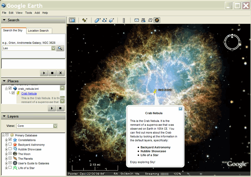
範例
下方範例說明如何建立 KML 檔案,以顯示「Google 地球」中的「蟹餅星雲」:
<kml xmlns="http://www.opengis.net/kml/2.2" hint="target=sky">
<Document>
  <Style id="CrabNebula">
    <BalloonStyle>
      <text><center><b>$[name]</b></center><br/>$[description]</text>
    </BalloonStyle>
  </Style>
  <Placemark>
    <name>Crab Nebula</name>
    <description>
      <![CDATA[
        This is the Crab Nebula.  It is the remnant of a supernovae that was
        observed on Earth in 1054 CE.  You can find out more about the Crab
        Nebula by looking at the information in the default layers, specifically:
        <ul>
          <li> <b>Backyard Astronomy</b>
          <li> <b>Hubble Showcase</b>
          <li> <b>Life of a Star</b>
        </ul>
        Enjoy exploring Sky!
      ]]>
    </description>
    <LookAt>
      <longitude>-96.366783</longitude>
      <latitude>22.014467</latitude>
      <altitude>0</altitude>
      <range>10000</range>
      <tilt>0</tilt>
      <heading>0</heading>
    </LookAt>
    <styleUrl>#CrabNebula</styleUrl>
    <Point>
      <coordinates>-96.366783,22.014467,0</coordinates>
    </Point>
  </Placemark>
</Document>
</kml>
這個檔案在 Google 地球中的顯示方式如下: