-
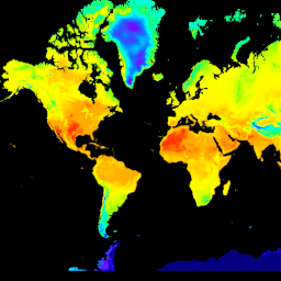
CFSR: Climate Forecast System Reanalysis(気候予測システム再分析)

国立環境予測センター(NCEP)の気候予測システム再分析(CFSR)は、全球の高解像度の大気-海洋-陸地表面-海氷結合システムとして設計、実行され、1 月から 32 年間の記録期間にわたるこれらの結合ドメインの状態の最良の推定値を提供します。 climate daylight flux forecast geophysical ncep -
CFSV2: NCEP 気候予測システム バージョン 2、6 時間ごとのプロダクトを調和
米国国立環境予測センター(NCEP)の気候予測システム(CFS)は、地球の大気、海洋、陸地、海氷の相互作用を表す完全結合モデルです。CFS は、NCEP の環境モデリング センター(EMC)で開発されました。運用 CFS が … にアップグレードされました。 climate daylight flux forecast geophysical ncep -
Daymet V4: 毎日の地表気象と気候の概要

Daymet V4 は、北米大陸、ハワイ、プエルトリコの毎日の気象パラメータのグリッド推定値を提供します(プエルトリコのデータは 1950 年から利用可能です)。これは、選択した気象観測所のデータとさまざまな補助データソースから導出されます。以前のバージョンと比較すると、Daymet は… climate daily daylight flux geophysical nasa -
ECMWF 準リアルタイム IFS 大気予報
このデータセットには、ECMWF 統合予報システム(IFS)によって 0.25 度の解像度で生成された大気モデル変数の 15 日間の予報が含まれています。ECMWF のリアルタイム予測のリリース後、1 日に 2 回新しいプロダクトがリリースされるため、これらを準リアルタイム(NRT)と呼びます。 climate dewpoint ecmwf forecast global humidity -
ERA5-Land Daily Aggregated - ECMWF Climate Reanalysis
ERA5-Land は、ERA5 と比較して解像度を高め、数十年にわたる陸地変数の変化を一貫して把握できる再解析データセットです。ERA5-Land は、ECMWF ERA5 気候再解析の陸上コンポーネントを再生して生成されています。再分析では、モデルデータと … を組み合わせます。 cds climate copernicus ecmwf era5-land evaporation -
ERA5-Land Hourly - ECMWF Climate Reanalysis

ERA5-Land は、ERA5 と比較して解像度を高め、数十年にわたる陸地変数の変化を一貫して把握できる再解析データセットです。ERA5-Land は、ECMWF ERA5 気候再解析の陸上コンポーネントを再生して生成されています。再分析では、モデルデータと … を組み合わせます。 cds climate copernicus ecmwf era5-land evaporation -
ERA5-Land 月次集計 - ECMWF 気候再解析
ERA5-Land は、ERA5 と比較して解像度を高め、数十年にわたる陸地変数の変化を一貫して把握できる再解析データセットです。ERA5-Land は、ECMWF ERA5 気候再解析の陸上コンポーネントを再生して生成されています。再分析では、モデルデータと … を組み合わせます。 cds climate copernicus ecmwf era5-land evaporation -
ERA5-Land 月別平均(1 日の時刻別) - ECMWF 気候再解析
ERA5-Land は、ERA5 と比較して解像度を高め、数十年にわたる陸地変数の変化を一貫して把握できる再解析データセットです。ERA5-Land は、ECMWF ERA5 気候再解析の陸上コンポーネントを再生して生成されています。再分析では、モデルデータと … を組み合わせます。 cds climate copernicus ecmwf era5-land evaporation -
FLDAS: Famine Early Warning Systems Network(FEWS NET)Land Data Assimilation System
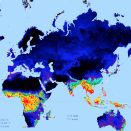
FLDAS データセット(McNally 他、2017 年)は、データが少ない発展途上国での食料安全保障の評価を支援するために設計されました。水分量、湿度、蒸発散量、平均土壌温度、総降水量など、気候に関連する多くの変数に関する情報が含まれています。FLDAS データセットは複数あります。 climate cryosphere evapotranspiration humidity ldas monthly -
GLIMS 2023: Global Land Ice Measurements From Space

Global Land Ice Measurements from Space(GLIMS)は、世界に推定 20 万ある氷河を繰り返し調査することを目的とした国際的な取り組みです。このプロジェクトは、氷河の面積、形状、表面速度、雪線などの測定値を含む、地球規模で包括的な陸氷のインベントリを作成することを目的としています。 cryosphere glacier glims ice landcover nasa -
GLIMS Current: Global Land Ice Measurements From Space

Global Land Ice Measurements from Space(GLIMS)は、世界に推定 20 万ある氷河を繰り返し調査することを目的とした国際的な取り組みです。このプロジェクトは、氷河の面積、形状、表面速度、雪線などの測定値を含む、地球規模で包括的な陸氷のインベントリを作成することを目的としています。 cryosphere glacier glims ice landcover nasa -
MOD10A1.061 Terra Snow Cover Daily Global 500m

MOD10A1 V6.1 Snow Cover Daily Global 500m プロダクトには、積雪、雪のアルベド、積雪率、品質評価(QA)データが含まれています。積雪データは、正規化差積雪指数(NDSI)やその他の条件テストを使用する積雪マッピング アルゴリズムに基づいています。全般 … albedo cryosphere daily geophysical global modis -
MOD10A2.061 Terra Snow Cover 8-Day L3 Global 500m

MOD10A2 は、Terra 衛星の MODIS からの積雪データセットです。このデータセットは、8 日間の最大積雪範囲を 500 m の解像度でレポートします。8 日間の合成期間が選択されたのは、それが正確なグラウンド トラックの繰り返しであるためです。 cryosphere daily geophysical global modis nasa -
MYD10A1.061 Aqua Snow Cover Daily Global 500m

MYD10A1 V6 Snow Cover Daily Global 500m プロダクトには、積雪、雪のアルベド、積雪率、品質評価(QA)データが含まれています。積雪データは、正規化差積雪指数(NDSI)やその他の条件テストを使用する積雪マッピング アルゴリズムに基づいています。全般 … albedo aqua cryosphere daily geophysical global