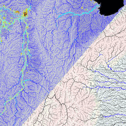
MERIT Hydro, MERIT DEM yükseklik verilerinin ve su kütlesi veri kümelerinin (G1WBM, GSWO ve OpenStreetMap) 1.0.3 sürümünden elde edilen, 3 yay saniyesi çözünürlüğe (~Ekvator'da 90 m) sahip yeni bir küresel akış yönü haritasıdır. MERIT Hydro, yeni bir …
[[["Anlaması kolay","easyToUnderstand","thumb-up"],["Sorunumu çözdü","solvedMyProblem","thumb-up"],["Diğer","otherUp","thumb-up"]],[["İhtiyacım olan bilgiler yok","missingTheInformationINeed","thumb-down"],["Çok karmaşık / çok fazla adım var","tooComplicatedTooManySteps","thumb-down"],["Güncel değil","outOfDate","thumb-down"],["Çeviri sorunu","translationIssue","thumb-down"],["Örnek veya kod sorunu","samplesCodeIssue","thumb-down"],["Diğer","otherDown","thumb-down"]],[],[],["MERIT Hydro offers a global flow direction map with a 3 arc-second resolution, derived from MERIT DEM elevation data and water body datasets (G1WBM, GSWO, OpenStreetMap). It utilizes elevation, flow-direction, and hydrography data. It offers supplementary visualization layers that share the same data origins and tag categories, offering additional tools for understanding the hydrography data. The dataset focuses on mapping water flow direction globally.\n"]]