Planet は、企業、政府、研究者、ジャーナリストが物理世界を理解して行動を起こすのに役立つ衛星データを毎日提供しています。ノルウェーの国際気候森林イニシアチブ(NICFI)を通じて、ユーザーは Planet の高解像度で分析可能な世界の熱帯地域のモザイクにアクセスできるようになりました。これにより、熱帯雨林の減少を抑制し、逆転させ、気候変動に対処し、生物多様性を保全し、非商用での持続可能な開発を促進できます。
-
NICFI 衛星データ プログラムの熱帯雨林モニタリング用ベースマップ - アフリカ
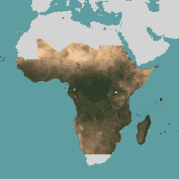
この画像コレクションは、熱帯林の減少を減らし、逆転させることを主な目的として、熱帯地域の高解像度衛星モニタリングへのアクセスを提供します。これにより、気候変動への対策、生物多様性の保全、森林の再生、復元、強化への貢献、持続可能な開発の促進など、さまざまな取り組みに貢献します。 basemaps forest nicfi planet planet-nicfi publisher-dataset -
NICFI 衛星データ プログラム 熱帯林モニタリング用ベースマップ - アメリカ大陸
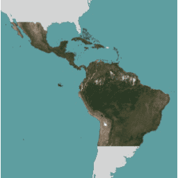
この画像コレクションは、熱帯林の減少を減らし、逆転させることを主な目的として、熱帯地域の高解像度衛星モニタリングへのアクセスを提供します。これにより、気候変動への対策、生物多様性の保全、森林の再生、復元、強化への貢献、持続可能な開発の促進など、さまざまな取り組みに貢献します。 basemaps forest nicfi planet planet-nicfi publisher-dataset -
熱帯林モニタリングのための NICFI 衛星データ プログラムの基本地図 - アジア
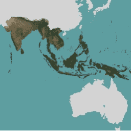
この画像コレクションは、熱帯林の減少を減らし、逆転させることを主な目的として、熱帯地域の高解像度衛星モニタリングへのアクセスを提供します。これにより、気候変動への対策、生物多様性の保全、森林の再生、復元、強化への貢献、持続可能な開発の促進など、さまざまな取り組みに貢献します。 basemaps forest nicfi planet planet-nicfi publisher-dataset