- Dataset Availability
- 1985-01-01T00:00:00Z–2018-12-31T00:00:00Z
- Dataset Provider
- Tsinghua University
- Earth Engine Snippet
-
ee.Image("Tsinghua/FROM-GLC/GAIA/v10") - Tags
Description
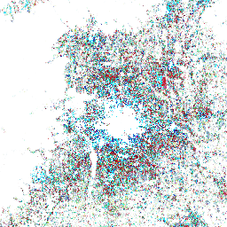
This dataset contains annual change information of global impervious surface area from 1985 to 2018 at a 30m resolution. Change from pervious to impervious was determined using a combined approach of supervised classification and temporal consistency checking. Impervious pixels are defined as above 50% impervious. The year of the transition (from pervious to impervious) can be identified from the pixel value, ranging from 34 (year: 1985) to 1 (year: 2018). For example, the impervious surface in 1990 can be revealed as the pixel value greater than 29 (see the lookup table). This dataset is temporally consistent, following the conversion from pervious (e.g., non-urban) to impervious (e.g., urban) monotonically. For more information about the mapping approach and assessment, see Annual maps of global artificial impervious area (GAIA) between 1985 and 2018 (Gong et al. 2020).
Bands
Resolution
30 meters
Bands
| Name | Min | Max | Description |
|---|---|---|---|
change_year_index |
1* | 34* | Year of the transition from from pervious to impervious. From 34 (year: 1985) to 1 (year: 2018) |
change_year_index Class Table
| Value | Color | Description |
|---|---|---|
| 1 | #014352 | 2018 |
| 2 | #1a492c | 2017 |
| 3 | #071ec4 | 2016 |
| 4 | #b5ca36 | 2015 |
| 5 | #729eac | 2014 |
| 6 | #8ea5de | 2013 |
| 7 | #818991 | 2012 |
| 8 | #62a3c3 | 2011 |
| 9 | #ccf4fe | 2010 |
| 10 | #74f0b9 | 2009 |
| 11 | #32bc55 | 2008 |
| 12 | #c72144 | 2007 |
| 13 | #56613b | 2006 |
| 14 | #c14683 | 2005 |
| 15 | #c31c25 | 2004 |
| 16 | #5f6253 | 2003 |
| 17 | #11bf85 | 2002 |
| 18 | #a61b26 | 2001 |
| 19 | #99fbc5 | 2000 |
| 20 | #188aaa | 1999 |
| 21 | #c2d7f1 | 1998 |
| 22 | #b7d9d8 | 1997 |
| 23 | #856f96 | 1996 |
| 24 | #109c6b | 1995 |
| 25 | #2de3f4 | 1994 |
| 26 | #9a777d | 1993 |
| 27 | #151796 | 1992 |
| 28 | #c033d8 | 1991 |
| 29 | #510037 | 1990 |
| 30 | #640c21 | 1989 |
| 31 | #31a191 | 1988 |
| 32 | #223ab0 | 1987 |
| 33 | #b692ac | 1986 |
| 34 | #2de3f4 | 1985 |
Terms of Use
Terms of Use
This work is licensed under a Creative Commons Attribution 4.0 International License. https://creativecommons.org/licenses/by/4.0/
Citations
Gong, P., Li, X., Wang, J., Bai, Y., Chen, B., Hu, T., ... & Zhou, Y. (2020). Annual maps of global artificial impervious area (GAIA) between 1985 and 2018. Remote Sensing of Environment, 236, 111510.
Explore with Earth Engine
Code Editor (JavaScript)
var dataset = ee.Image('Tsinghua/FROM-GLC/GAIA/v10');

var visualization = {
  bands: ['change_year_index'],
  min: 0,
  max: 34,
  palette: [
    '014352', '1a492c', '071ec4', 'b5ca36', '729eac', '8ea5de',
    '818991', '62a3c3', 'ccf4fe', '74f0b9', '32bc55', 'c72144',
    '56613b', 'c14683', 'c31c25', '5f6253', '11bf85', 'a61b26',
    '99fbc5', '188aaa', 'c2d7f1', 'b7d9d8', '856f96', '109c6b',
    '2de3f4', '9a777d', '151796', 'c033d8', '510037', '640c21',
    '31a191', '223ab0', 'b692ac', '2de3f4',
  ]
};

Map.setCenter(-37.62, 25.8, 2);

Map.addLayer(dataset, visualization, 'Change year index');